(Author's note 5/18/2020: ASTER Level 1 Precision Terrain Corrected data are now available to the public at no charge. These data are available from Data Pool, Earthdata Search, and more.)
In March 2015, the Land Processes Distributed Active Archive Center (LP DAAC) began processing the Advanced Spaceborne Thermal Emission and Reflection Radiometer (ASTER) Level 1 Precision Terrain Corrected Registered At-Sensor Radiance (AST_L1T) product. The new AST_L1T product provides quick turn-around of consistent GIS-ready data as a multi-file product, which includes a HDF-EOS data file, full-resolution composite images (FRI) as GeoTIFFs for tasked sensors (e.g. VNIR/SWIR and TIR), and associated metadata files. In addition, each AST_L1T granule contains related products including low-resolution browse, and when applicable, a QA browse and QA text report.
NASA LP DAAC has created the AST_L1T product by applying modified Landsat geometric algorithms to ASTER Level 1 data. The AST_L1T algorithm applies Earth and satellite models, control points, and elevation models, ultimately projecting the result onto a rotated north-up map at full instrument resolution.
AST_L1T features a single resampling from the AST_L1A for use in investigations, or in the future, as input into Level 2 Earth surface parameter generation, such as surface reflectance and temperature emissivity.
AST_L1T granule names are constructed as L1T Short Name (e.g. AST_L1T), Collection Version (e.g. 003), Start Date-Time-Group (e.g. mmddyyyyhhmmss), Production Date-Time-Group (e.g. mmddyyhhmmss), and Processing Random Number (e.g. 12345).
Each scene contains multiple files. Please refer to the table below for file extension interpretation.
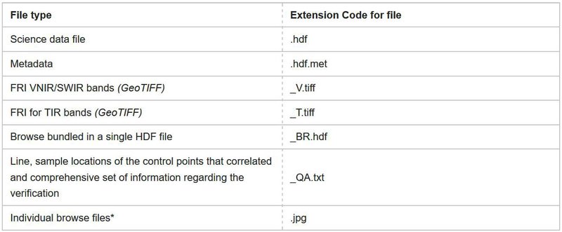
*The individual browse files may end in _BR_#.jpg where the # may be 2, 3, or 4. What these numbers represent depends on how many browse jpeg files are included in the scene/granule. If there are three browse, then 2 = VNIR/SWIR, 3 = TIR, and 4 = QA. Alternately, if only two browse are available, then 2 = VNIR/SWIR or TIR depending on the sensors acquired and 3 = TIR or QA. Then if only 1 browse is available it may be VNIR/SWIR or TIR depending on sensors acquired.
The AST_L1T data are available over the United States and territories at no charge to all users. In addition, approved NASA supported researchers and their affiliates, educational users, and federal partners may order AST_L1T from the LP DAAC global collection. To become approved for global access, users must first register by creating a NASA account to search and order, then complete and submit an application form available online at https://lpdaacaster.cr.usgs.gov/afd/index.php.
For further information, please refer to the AST_L1T Product page, or contact User Services. Additional supporting documentation such as the AST_L1T ATBD, User Guide, and Product Specification will be released as they become available.