The most destructive wildfire in Colorado history stared on June 23, in the pine forests just northwest of Colorado Springs, Colorado. The fire spread quickly burning over 5,000 acres by June 26 and more than 18,000 acres the next day. Nearly 350 homes were destroyed when the fire burned into northwest Colorado Springs. Hot, dry weather and shifting winds made battling the fire extremely challenging.
Local attractions such as the Air Force Academy, garden of the Gods, Pike's Peak Highway, and the cog railroad were closed when mandatory evacuation orders were in place.
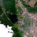
The Waldo Canyon Fire was 95% contained when this simulated natural color image was acquired by the Advanced Spaceborne Thermal Emission and Reflection Radiometer (ASTER) is orbiting Earth on the Terra spacecraft at an elevation of 438 miles. Terra and ASTER are key components on the National Aeronautics and Space Administration’s (NASA) Earth Observing System. ASTER is successfully completing a global mapping mission, with over two million 1,390 square mil multispectral scenes archived since launch in 1999. Data are available from the NASA Land Processes Distributed Active Archive Center at the U.S. Geological Survey Earth Resources Observation and Science (EROS) Center near Sioux Falls, South Dakota.