(Author's Note 2/18/2022: At the time of publishing these references were available online, some resources may no longer be available.)

A mosaicked MODIS Surface Reflectance (MOD09GA and MYD09GA) image of Hurricane Katrina making landfall on August 29, 2005.
Granule IDs:
MYD09GA.A2005241.h09v05.005.2008061055945
MYD09GA.A2005241.h09v06.005.2008061062850
MYD09GA.A2005241.h10v05.005.2008061055410
MYD09GA.A2005241.h10v06.005.2008061060023
MYD09GA.A2005241.h11v05.005.2008061055518
MYD09GA.A2005241.h11v06.005.2008061063227
MOD09GA.A2005241.h11v06.005.2008061004050
MOD09GA.A2005241.h10v06.005.2008061002650
August 23, 2015 marks the 10-year anniversary of Hurricane Katrina, a Category 5 hurricane which produced wind speeds over 274 kilometers per hour (170 miles per hour) and caused severe destruction from Florida to Louisiana. The storm that would become Katrina formed over the Bahamas on August 23, 2005 and reached hurricane status two days later as it passed over southern Florida. Katrina made landfall over Mississippi and Louisiana on the morning of August 29, 2005 as a Category 3 Hurricane, which means it was producing winds speeds of 178 to 209 kilometers per hour (approximately 111 to 129 miles per hour). According to the National Hurricane Center, the massive storm caused severe destruction throughout the area totaling $108,000,000,000 worth of damage. To date it is the most expensive hurricane in the history of the United States
Hurricane Katrina caused environmental changes in the shape, elevation, and even locations of islands and wetlands, as well as the loss of sand, sediment, and vegetation. Scientists can use satellite imagery to better understand the impact hurricanes have on ecological areas by using various types of satellite data to detect changes the area has experienced. The NASA Terra Advanced Spaceborne Thermal Emission and Reflection Radiometer (ASTER) sensor is especially useful for this kind of research due to its ability to capture specific areas at defined points in time.
The ASTER images below illustrate some of the damage inflicted on the Chandeleur Barrier Islands, located east of the Mississippi Delta, in the aftermath of Hurricane Katrina. The Chandeleur Barrier Islands act as a natural layer of protection for the Chandeleur Sound and Biloxi marsh, assisting in limiting the impact of ocean waves, storm surges, and salinity intrusion that can harm inner wetlands and the mainland. As part of the Breton National Wildlife Refuge, these islands are identified as a critical habitat for wildlife and are a very important stop for many birds migrating between North and South America. Winds and storm surge from Hurricane Katrina washed out the once 40 kilometer (24.8 mile) – long dunes, and left pockets of marsh fragments in its wake. According to Sallenger and others (2009), a total of 82% of the islands’ surface area was lost due to Hurricane Katrina. The height of the islands was reduced from 5 meters (16.4 feet) to less than a half meter (1.6 feet). According to Dr. List, if barrier islands were to disappear it could increase the rate of deterioration of the wetlands the islands are currently protecting.
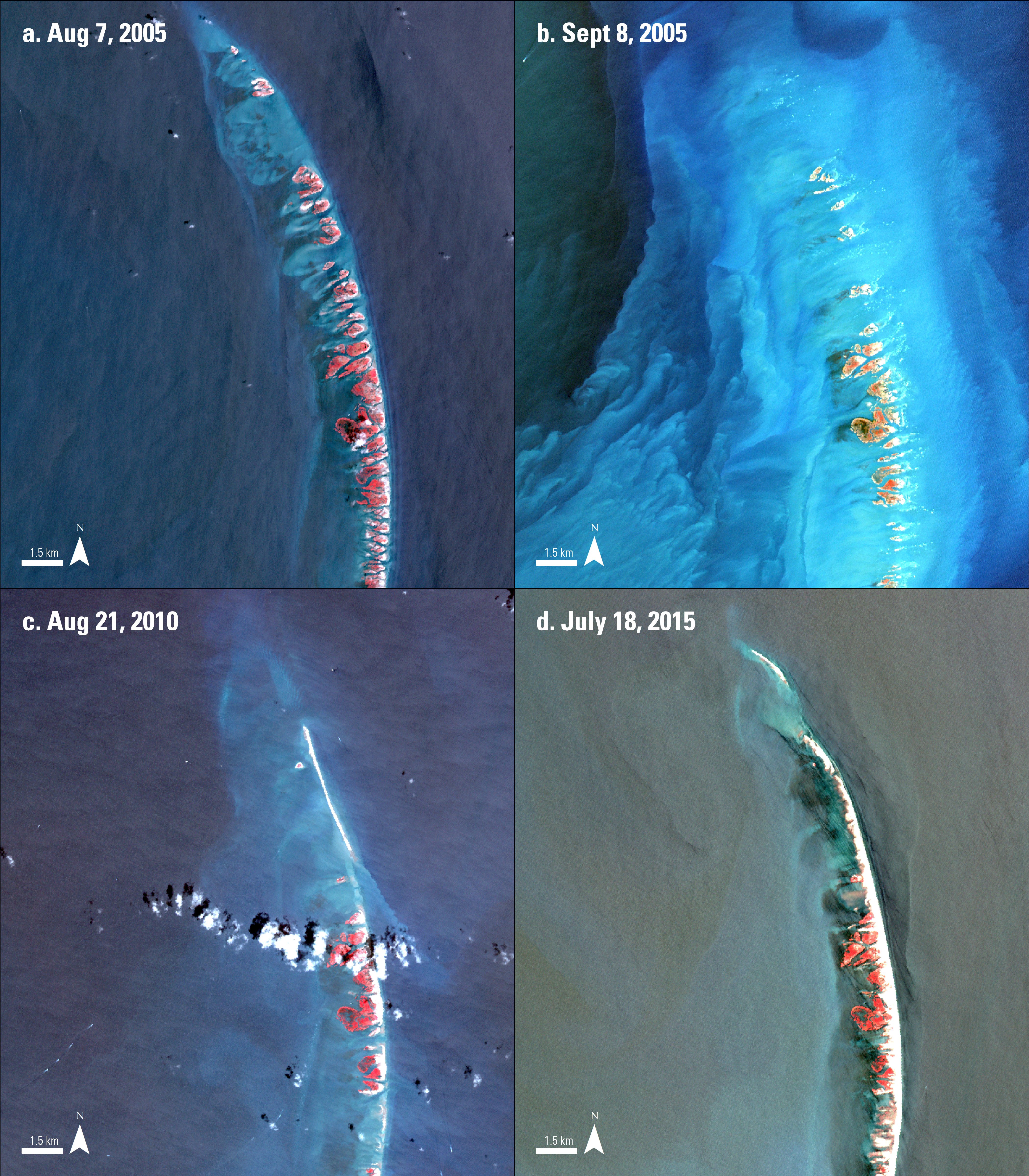
Four infrared false color AST_L1B images of the northern tip of the Chandeleur Islands.
An image of the islands captured during August of 2005 before Hurricane Katrina. The red color in these images indicates vegetation.
The damage from Hurricane Katrina is seen in this image from September 8, 2005. The loss of sand on the islands and land fragments converting to small pockets of marsh are evident in this image. The uplifted sand and sediment is shown in the water surrounding the islands.
An image of the islands captured on August 21, 2010, five years after Hurricane Katrina. The image shows further damage caused by hurricanes Rita (2005), Gustav (2008) and Ida (2009).
Recently captured on July 28, 2015, this image displays the islands as they were during the summer of 2015. Since 2010, the region has only experienced one hurricane, Hurricane Isaac. The lull in hurricanes has allowed the islands to have time to slowly rebuild.
Granule IDs:
AST_L1B_00308072005164249_20101107022539_8121
AST_L1B_00309082005164230_20101105183828_23951
AST_L1B_00308212010164312_20100827202729_5260
AST_L1B_00307182015164444_20150720124649_24803
References: (Author's Note 5/15/2020: At the time of publishing these references were available online, some resources may no longer be available.)
Dreher, C., Flocks, J., and Lavoie, D., 2007, Assessing the resilience of a vital barrier-island chain – Chandeleur and Breton Islands, Louisiana, accessed August 5, 2015, at http://soundwaves.usgs.gov/2007/12/fieldwork2.html.
Government Publishing Office, 2006, The impact of Hurricanes Katrina and Rita on the National Wildlife Refuge System oversite hearing, accessed August 5, 2015, at http://www.gpo.gov/fdsys/pkg/CHRG-109hhrg26654/html/CHRG-109hhrg26654.htm.
List, J., Louisiana Barrier Islands: A Vanishing Resource, accessed August 19, 2015, at http://pubs.usgs.gov/fs/barrier-islands/.
National Climatic Data Ceneter, 2005, Hurricane Katrina, accessed August 19, 2015, at http://www.ncdc.noaa.gov/extremeevents/specialreports/Hurricane-Katrina.pdf.
National Geographic, 2010, Hurricane Katrina: The essential time line, accessed July 16, 2015, at http://news.nationalgeographic.com/news/2005/09/0914_050914_katrina_timeline.html.
National Hurricane Center, 2011, The deadliest, costliest, and most intense United States tropical cyclones from 1851 to 2010 (and other frequently request hurricane facts), accessed August 11, 2015 at http://www.nhc.noaa.gov/pdf/nws-nhc-6.pdf.
National Weather Service Natural Hurricane Center, Saffir-Simpson hurricane wind scale, accessed July 16, 2015, at http://www.nhc.noaa.gov/aboutsshws.php.
National Wildlife Federation, 2006, When hurricanes hit habitat, accessed July 27, 2015, at https://www.nwf.org/News-and-Magazines/National-Wildlife/News-and-Views/Archives/2006/When-Hurricanes-Hit-Habitat.aspx.
Sallenger, A., Wright, C., Howd, P., Doran, K., and Guy, K., 2009, Extreme coastal changes on the Chandeleur Islands, Louisiana, during and after Hurricane Katrina, accessed August 5, 2015, at http://pubs.usgs.gov/sir/2009/5252/downloads/Chapter-B/Chapter-B.pdf.
Tibbetts, John, 2006, Louisiana’s wetlands— A lesson in nature appreciation: Environmental Health Perspectives, v. 114, no 1, p. A40–A43, at http://www.ncbi.nlm.nih.gov/pmc/articles/PMC1332684/.
U.S. Fish & Wildlife Service, 2013, Breton National Wildlife Refuge, accessed July 27, 2015, at http://www.fws.gov/breton/.
Material written by Danielle Golon1
1 Innovate!, Inc., contractor to the U.S. Geological Survey, Earth Resources Observation and Science (EROS) Center, Sioux Falls, South Dakota, USA. Work performed under USGS contract G10PC00044 for LP DAAC2.
2 LP DAAC Work performed under NASA contract NNG14HH33I.