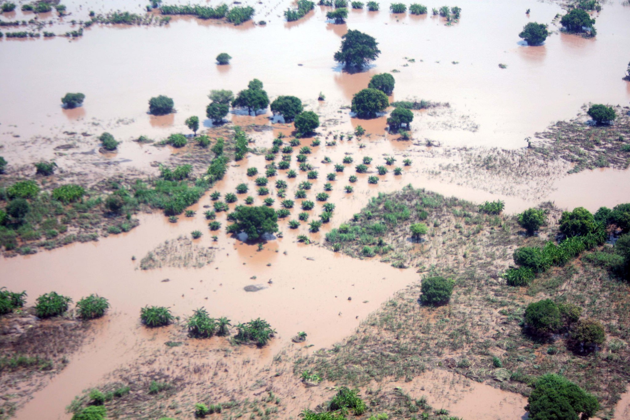
Cropland submerged by floodwaters on the Lower Shire in southern Malawi. This photo was taken on January 16, 2015.
Cropland submerged by floodwaters on the Lower Shire in southern Malawi. This photo was taken on January 16, 2015.
(Author's Note 3/1/2024: At the time of publishing these references were available online, some resources may no longer be available.)
Heavy rains occurred over the Shire (Chire) River region in southern Malawi and north-central Mozambique from December 2014 to early February 2015. The rains have caused the water level of the Shire River to rise. As a result, more than 1,200 square kilometers (120,000 hectares) of land has been submerged, infrastructure has been damaged, and numerous deaths and missing persons have been reported. Seasonal rains are typical in the region from December to March, but the rains that began this past December were unusually heavy. The increased intensity is partially due to rains brought in mid-January by Tropical Cyclone Bansi as it passed over the coast of southwestern Africa.
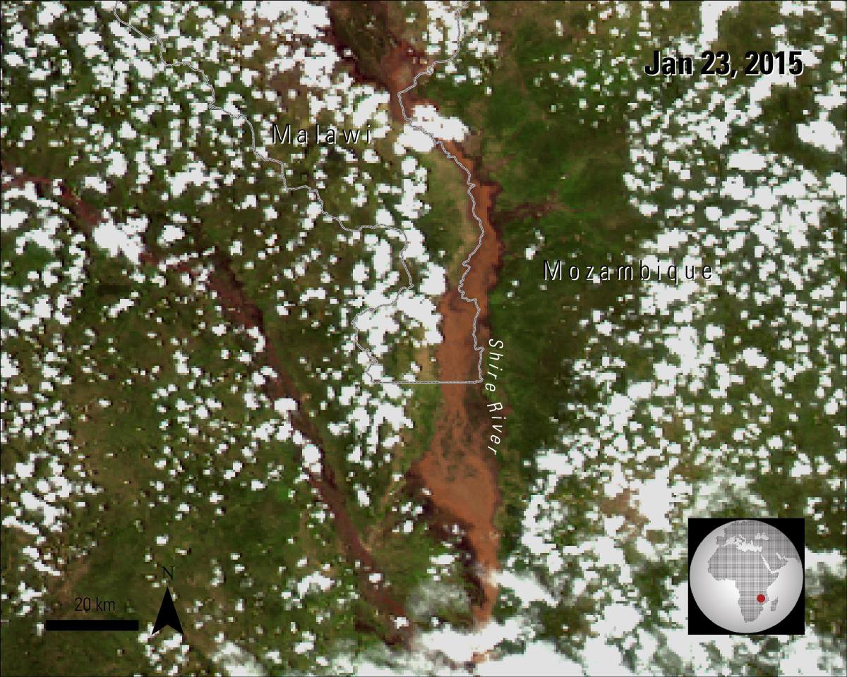
The Moderate Resolution Imaging Spectroradiometer (MODIS) instrument aboard NASA’s Aqua satellite captured the images below of the Shire River. The left image, from November 29, 2014, is from before the rainy season started and shows mostly brown land indicating that it is dry. The image on the right, from January 23, 2015, shows much more green land, indicating vegetation growth, but also the expansion of the river onto the surrounding land.
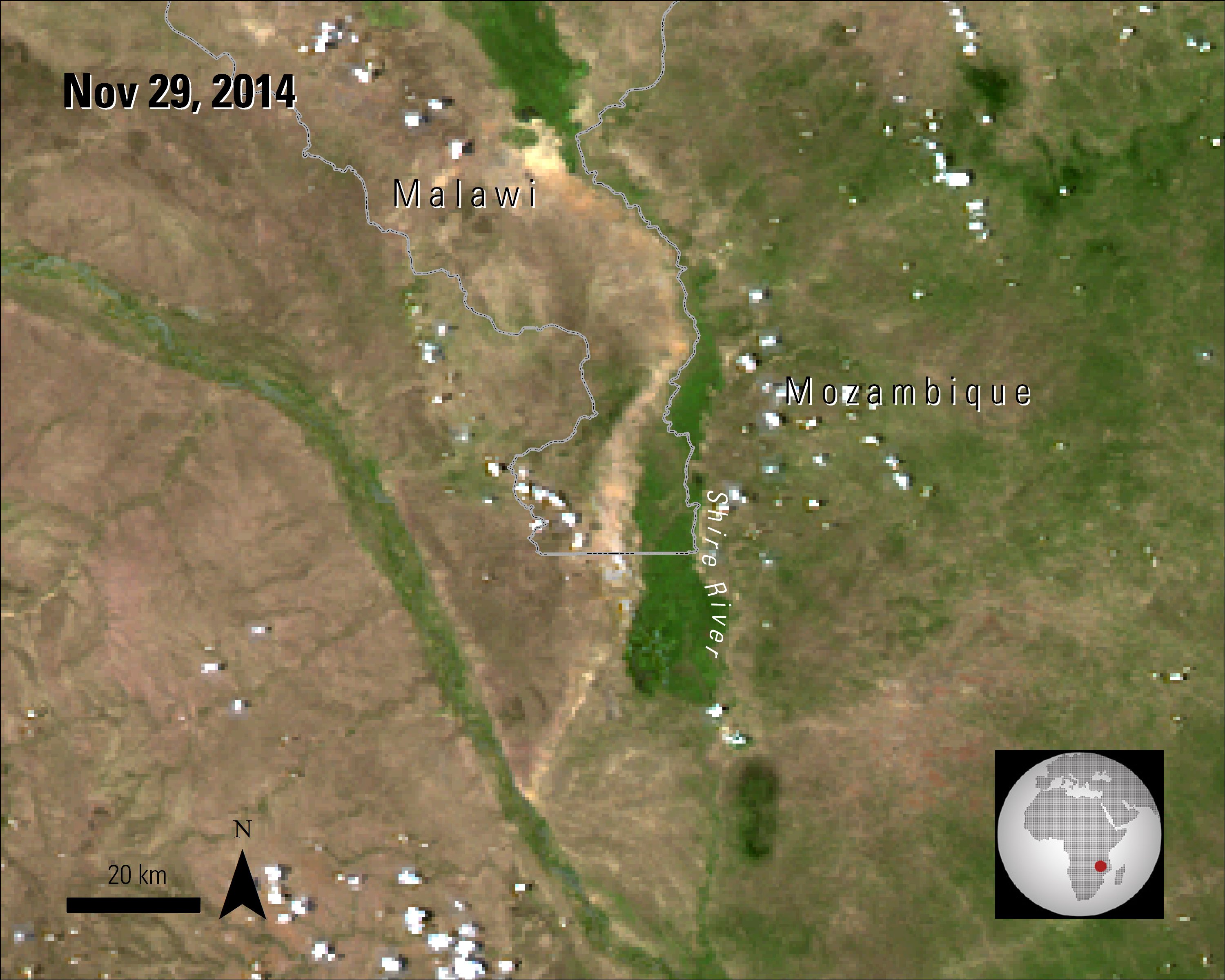
Left Image: An Aqua MODIS image captured on November 29, 2014, before the rainy season began.
Granule ID:
MYD09GA.A2014333.h21v10.005.2014335070413
Right image: An Aqua MODIS image captured on January 23, 2015, after heavy rains caused the Shire River to swell.
Granule ID:
MYD09GA.A2015023.h21v10.005.2015025071357
References:
Allison, S., 2015, From drought to deluge: Floods devastate Malawi and Mozambique, accessed January 29, 2015 at http://www.dailymaverick.co.za/article/2015-01-19-from-drought-to-deluge-floods-devastate-malawi-and-mozambique/#.VNERqGjF_To.
BBC, 2015, Still thirsty after Malawi’s flood, accessed January 29, 2015 at http://www.bbc.com/news/magazine-30980324.
Brakenridge, G.R., Slayback, D., Kettner, A.J., Policelli, F., De Groeve, T., and Cohen, S., 2014, Current Conditions and Maximum Flood Extent, 2015 Flooding in Malawi and Southern Mozambique, DFO Event 4219, accessed January 27, 2015 at http://floodobservatory.colorado.edu/Version3/2015Malawi4219.html.
Department of Disaster Management Affairs (DoDMA) and United Nations Office of the Resident Coordinator (UNRCO), 2015, Malawi: Floods Situation Report No. 7, accessed February 8, 2015 at http://reliefweb.int/sites/reliefweb.int/files/resources/Malawi%20Floods-DoDMA-UNRCO%20Situation%20Report_n7-06Feb2015.pdf
FAO, 2015, Farmers in Malawi need urgent help after heavy flooding, accessed January 29, 2015 at http://www.fao.org/news/story/en/item/275944/icode/.
Jury, M.R., 2014, Malawi’s Shire River Fluctuations and Climate, J. Hydrometeorology, 15, 2039 – 2049. [Also available at http://dx.doi.org/10.1175/JHM-D-13-0195.1].
UN Country Team Mozambique, 2015, Mozambique: Flooding – Office of the Resident Cooridnator, Situation Report No. 3 (As of 09 February 2015), accessed February 13, 2015 at http://reliefweb.int/sites/reliefweb.int/files/resources/Mozambique-UNRCO-Situation%20Report%203_09%2002%2015_Final.pdf.
Material written by: Lindsey Harriman1
1 Innovate!, Inc., contractor to the U.S. Geological Survey, Earth Resources Observation and Science (EROS) Center, Sioux Falls, South Dakota, USA. Work performed under USGS contract G10PC00044 for LP DAAC2.
2 LP DAAC Work performed under NASA contract NNG14HH33I.