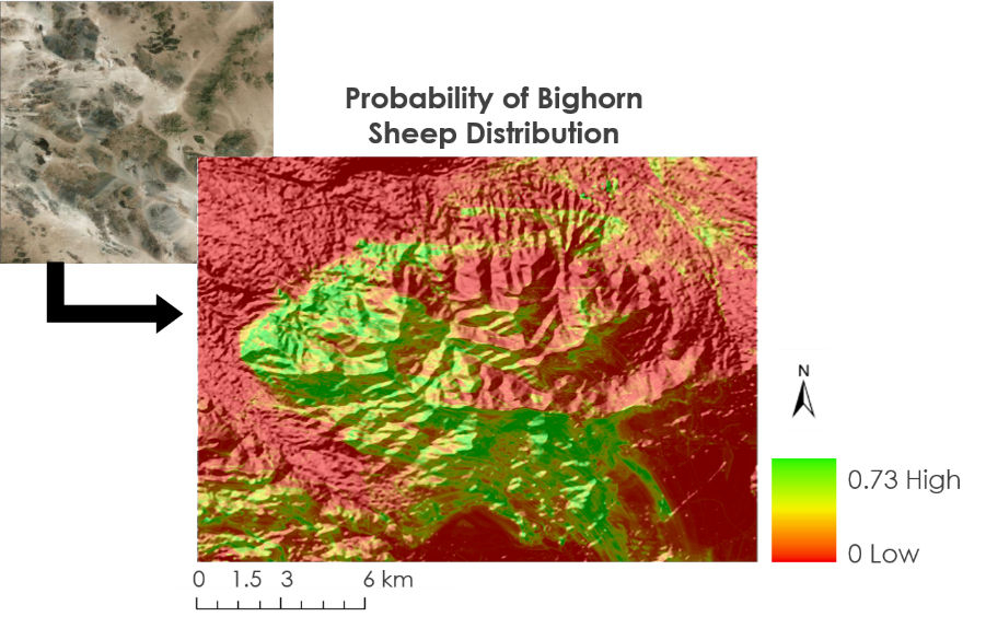
A map showing the probability of bighorn sheep distribution within the Granite Mountains in California. This map shows areas where bighorn sheep are more likely to exist.
Image courtesy of the Mojave Desert Ecological Forecasting Team.
A map showing the probability of bighorn sheep distribution within the Granite Mountains in California. This map shows areas where bighorn sheep are more likely to exist.
Image courtesy of the Mojave Desert Ecological Forecasting Team.
(Author's Note 3/1/2024: At the time of publishing these references were available online, some resources may no longer be available.)
During the fall 2018 term of NASA’s DEVELOP National Program, participants used geospatial data and technologies to investigate, analyze, and monitor several issues around the world. Some of the topics explored throughout the term included agriculture, health, biodiversity, air pollution, extreme weather, changing ecologies, fire, natural disasters, water resources, habitat restoration, and urbanization. Each project completed by a DEVELOP team is conducted in partnership with agencies or organizations local to the study area. Fundamental to the analytical and geospatial component of each of these projects is NASA Earth science remote sensing data. Several of these projects used data distributed by the LP DAAC, including data collected by the Advanced Spaceborne Thermal Emission and Reflection Radiometer (ASTER) sensor aboard NASA’s Terra satellite, the Moderate Resolution Imaging Spectroradiometer (MODIS) sensor aboard NASA’s Terra and Aqua satellites, and NASA’s Shuttle Radar Topography Mission (SRTM), which flew aboard the space shuttle Endeavour in February 2000.
All projects conducted in the fall term, as well as in past terms, can be found in the DEVELOP archive.
Bighorn sheep are an important species in the Mojave Desert, both ecologically and culturally. These animals require extremely selective food types and elevation ranges to survive and thrive in their environment. Environmental degradation of their habitat combined with the need for specific food and elevations have caused these animals to split off into mini herds, making it hard for researchers to monitor and manage the current populations. A previous DEVELOP project used NASA data to study precipitation and vegetation greenness in the bighorn sheep’s habitat. This previous team found that additional parameters were needed to be studied in order to accurately assess bighorn sheep herds and to predict future distribution. In the fall of 2018, the Mojave Desert Ecological Forecasting team returned to the project to further examine the bighorn sheep’s habitat in the Mojave Desert. The team used data from NASA’s LP DAAC, including Terra MODIS vegetation indices data (MOD13Q1), to examine vegetation in the study area; Terra ASTER Global Digital Elevation Model data (ASTGTM) to identify the topography of the area; and soil moisture data from NASA’s National Snow and Ice Data Center (NSIDC) to study how these factors influence habitation selection. The team then incorporated these data into habitat modeling software to model current habitat ranges and to predict future ranges and ideal foraging areas for these animals. The results from this project will help better inform project partners, including the National Park Service and the California Department of Fish and Wildlife, of potential areas that could benefit from more extensive management methods and expanded monitoring.
About the NASA DEVELOP National Program
The DEVELOP National Program is part of NASA’s Applied Sciences Program. Participants from around the country join the DEVELOP program for 10-week terms to apply data acquired by NASA Earth-observing satellites to bridge the gap between science and society. DEVELOP participants work with non-profit, local, state, and federal partners to create maps and other products in eight focus areas, including Food Security & Agriculture, Disasters, Ecological Forecasting, Energy, Health and Air Quality, Urban Development, Water Resources, and Transportation & Infrastructure.
Any use of trade, firm, or product names is for descriptive purposes only and does not imply endorsement by the U.S. Government.
References:
Mojave Desert Ecological Forecasting, NASA DEVELOP National Program, 2018, Sheepishly picky, accessed February 3, 2020, at https://youtu.be/k8VweLBtaMk.
Moneymaker, B., Au, M., Beltran, G., and Kasraee, N., 2018, Mojave Desert Ecological Forecasting: Monitoring bighorn sheep habitat by assessing vegetation, topography, and soil moisture, accessed February 3, 2020, at https://develop.larc.nasa.gov/2018/fall/MojaveDesertEco.html.
Written by: Danielle Golon1, Brigitte Moneymaker3, Manda Au3, Gisela Beltran3, Neda Kasraee3, Amanda Clayton4
1 Innovate!, Inc., contractor to the U.S. Geological Survey, Earth Resources Observation and Science (EROS) Center, Sioux Falls, South Dakota, USA. Work performed under USGS contract G15PC00012 for LP DAAC2.
2 LP DAAC Work performed under NASA contract NNG14HH33I.
3 SSAI NASA DEVELOP National Program5, NASA Jet Propulsion Laboratory, Pasadena, California, USA.
4 SSAI, NASA DEVELOP National Program5, Langley Research Center, Hampton, Virginia, USA.
5 SSAI NASA DEVELOP Work performed under NASA contract NNL16AA05C