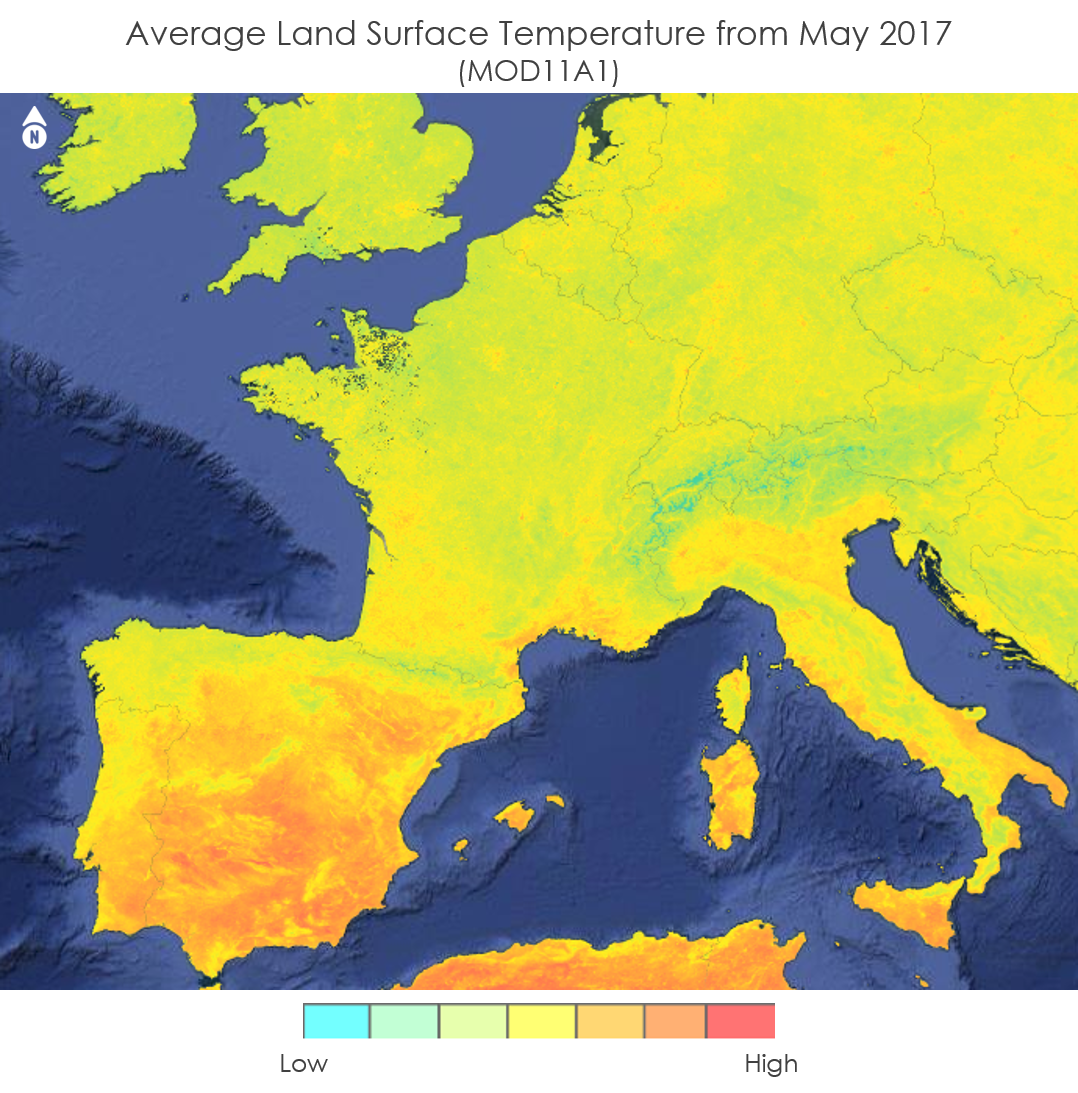
An average of LST values for the month of May in Western Europe using the Daily Terra MODIS LST data product. These data were used as an input data layer for the Google Earth Engine tool created by the DEVELOP team. Image courtesy of the Western Europe Health & Air Quality II “An Interactive Model of Mosquito Presence and Distribution to Assist Vector-Borne Disease Management in Western Europe” project team.
An average of LST values for the month of May in Western Europe using the Daily Terra MODIS LST data product. These data were used as an input data layer for the Google Earth Engine tool created by the DEVELOP team. Image courtesy of the Western Europe Health & Air Quality II “An Interactive Model of Mosquito Presence and Distribution to Assist Vector-Borne Disease Management in Western Europe” project team.
During the Spring 2018 Term of NASA’s DEVELOP National Program, participants used geospatial data and technologies to investigate, analyze, and monitor several issues around the world. Some of the topics explored throughout the term included invasive species, pollution, crop diversity, extreme weather, changing ecologies, wildfires, disease, water resources, archaeological preservation, and urbanization. Each project completed by a DEVELOP team is conducted in partnership with agencies or organizations local to the study area. Fundamental to the analytical and geospatial component of each of these projects is NASA Earth science remote sensing data. Two of these projects used data collected by the Moderate Resolution Imaging Spectroradiometer (MODIS) sensor on board NASA’s Terra and Aqua satellites and distributed by the LP DAAC.
All projects conducted in the Spring Term, as well as in past terms, can be found in the DEVELOP archive.
Mosquitos spread deadly vector-born illnesses to millions of people worldwide. The reach of these diseases is increasing as mosquitos are spreading via the numerous modes of travel throughout Europe. The NASA DEVELOP project, “An Interactive Model of Mosquito Presence and Distribution to Assist Vector-Borne Disease Management in Western Europe,” used NASA Earth observation data, combined with the Global Mosquito Alert Consortium’s citizen science data, to create an open source mosquito habitat suitability map with Google Earth Engine.
The DEVELOP team used geospatial data from the Terra satellite’s MODIS sensor, including Daily and Monthly Land Surface Temperature (LST) data (MOD11A1 and MOD11C3), Daily Surface Reflectance data (MOD09GA), Monthly Normalized Difference Vegetation Index (NDVI) data (MOD13C2), and Combined Terra Aqua MODIS Yearly Land Cover data (MCD12Q1 Version 5). They combined these data with other mosquito habitat-influencing data, which can be used to predict where mosquitos might exist, including elevation, humidity, precipitation, soil moisture, population density, and travel routes. Finally, the team examined data provided from GLOBE Observer, a citizen science mobile app that allows users to report occurrences of mosquito habitat, presence, and larvae. The team then incorporated these data into their interactive mosquito habitat suitability map. This map allows users to visualize where mosquitos are likely to exist and what environmental factors are present in the area.
The habitat suitability map created from this project will be available to the general public and can be used by researchers and public health officials to improve prediction models to help monitor and mitigate mosquito-borne diseases in Western Europe.
Note: Combined Terra and Aqua MODIS Yearly Land Cover Version 6 data are now available from the LP DAAC.
Watch this video created by the Western Europe Health & Air Quality II Team to learn more about their project and how they used NASA Earth science remote sensing data.
About the NASA DEVELOP National Program
The DEVELOP National Program is part of NASA’s Applied Sciences Program. Participants from around the country join the DEVELOP program for 10-week terms to apply data acquired by NASA Earth-observing satellites to bridge the gap between science and society. DEVELOP participants work with non-profit, local, state, and federal partners to create maps and other products in eight focus areas, including Agriculture & Food Security, Disasters, Ecological Forecasting, Energy, Health and Air Quality, Urban Development, Water Resources, and Transportation & Infrastructure.
Any use of trade, firm, or product names is for descriptive purposes only and does not imply endorsement by the U.S. Government.
References:
Western Europe Health & Air Quality II, NASA DEVELOP National Program, 2018, Mobile mosquito, accessed July 27, 2018, at https://youtu.be/cjPPi_Fc5gI.
Mancini, G., Heslin, J., Lenske, V, Lubkin, S and Silva, L., 2018, Western Europe Health & Air Quality II: An Interactive Model of Mosquito Presence and Distribution to Assist Vector-Borne Disease Management in Western Europe, accessed July 27, 2018, at https://develop.larc.nasa.gov/2018/spring/WesternEuropeHealthAQII.html.
Written by: Danielle Golon1, Gia Mancini3, Julia Heslin3, Victor Lenske3, Dr. Sara Lubkin3 Luisa Silva3, Amanda Clayton4
1 Innovate!, Inc., contractor to the U.S. Geological Survey, Earth Resources Observation and Science (EROS) Center, Sioux Falls, South Dakota, USA. Work performed under USGS contract G15PD00467 for LP DAAC2.
2 LP DAAC Work performed under NASA contract NNG14HH33I.
3NASA DEVELOP Western Europe Health & Air Quality II Team, Maryland NASA’s Goddard Space Flight Center.
4 SSAI, NASA DEVELOP National Program, Langley Research Center, Hampton, Virginia, USA.