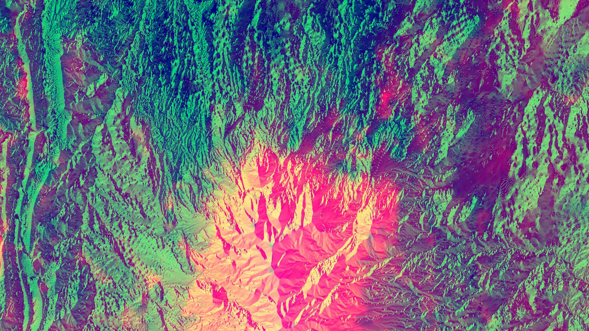
Suomi NPP NASA VIIRS NDVI data over the Henry Mountains in southern Utah from late June 2019, composited with elevation and aspect data from the National Elevation Dataset. Lighter yellow and pink colors show areas with higher elevation and a higher vegetation concentration. These areas indicate higher live fuel moisture content.
Image courtesy of the Great Basin Ecological Forecasting II Team.
During the spring 2020 term of NASA’s DEVELOP National Program, participants used geospatial data and technologies to investigate, analyze, and monitor several issues around the world. Some of the topics explored throughout the term included air quality, drought, flooding, habitat restoration and management, land cover change, urbanization, water resources and quality, and wildfires. Each project completed by a DEVELOP team is conducted in partnership with agencies or organizations local to the study area. Fundamental to the analytical and geospatial component of each of these projects is NASA Earth science remote sensing data. Several of these projects used data distributed by the Land Processes Distributed Active Archive Center, including data collected by the Moderate Resolution Imaging Spectroradiometer (MODIS) sensor aboard NASA’s Terra and Aqua satellites, the Visible Infrared Imaging Radiometer Suite (VIIRS) sensor aboard the joint NASA/NOAA Suomi National Polar-orbiting Partnership (Suomi NPP) satellite, and NASA’s Shuttle Radar Topography Mission (SRTM), which flew aboard the space shuttle Endeavour in 2000.
All projects conducted in the spring term, as well as in past terms, can be found in the DEVELOP archive.
Wildfires have become a hot topic as they have increased in frequency and size in recent years. These fires are a concern especially in the eastern Great Basin (EGB) region, covering parts of Arizona, Colorado, Idaho, Utah, and Wyoming in the United States. One measurement that can be used to predict wildfire risk in an area is Live Fuel Moisture (LFM). LFM is the percentage of wet content to dry content in vegetation. The drier the vegetation, the higher the chance it will catch fire. Currently, the land managers of the EGB can derive LFM levels from only 165 in situ sites. The Great Basin Ecological Forecasting II DEVELOP team set out to use NASA Earth science remote sensing data to provide more accurate bi-weekly LFM estimates of the EGB for their partners, the Bureau of Land Management, the National Weather Service, and the Great Basin Coordination Center. To do this the team created a model to reflect low, moderate, and high LFM content in the EGB. This model incorporated Evapotranspiration (ET) data from the Aqua (MYD16A2) and Terra (MOD16A2) MODIS satellite sensors; Normalized Difference Water Index (NDWI) (MOD09A1) from the Terra MODIS satellite sensor; NASA’s 2-band Enhanced Vegetation Index (EVI2) and Normalized Difference Vegetation Index (NDVI) data (VNP13A1), and Fraction of Photosynthetically Active Radiation (FPAR) and Leaf Area Index (LAI) (VNP15A2H) from the Suomi NPP VIIRS satellite sensor; and Elevation and Aspect from the National Elevation Dataset. The team used the 2019 wildfire season as their study period and then validated their results using in situ data. The team then created a forecast map of the 2020 season. The model created by the team will be able to help their partners make more informed decisions for resource allocation for future wildfires in the EGB.
Watch this video created by the Great Basin Ecological Forecasting II DEVELOP team to learn more about their project and how they used NASA Earth science remote sensing data.
About the NASA DEVELOP National Program
The DEVELOP National Program is part of NASA’s Applied Sciences Program. Participants from around the country join the DEVELOP program for 10-week terms to apply data acquired by NASA Earth-observing satellites to bridge the gap between science and society. DEVELOP participants work with non-profit, local, state, and federal partners to create maps and other products in eight focus areas, including Food Security & Agriculture, Disasters, Ecological Forecasting, Energy, Health & Air Quality, Urban Development, Water Resources, and Transportation & Infrastructure.
Any use of trade, firm, or product names is for descriptive purposes only and does not imply endorsement by the U.S. Government.
References:
Pirrie, G., Bierly, G., King, A., and Mistick, K., 2020, Great Basin Ecological Forecasting II— Assessing and forecasting live fuel moisture content of wildfire fuels for the Eastern Great Basin to improve wildfire timing and severity predictions: NASA DEVELOP National Program web page, accessed June 12, 2020, at https://develop.larc.nasa.gov/2020/spring/GreatBasinEcoII.html.
NASA DEVELOP National Program, 2020, The crown fuel: Forecasting live fuel moisture to better predict wildfires: NASA DEVELOP National Program video, 00:03:06, posted May 8, 2020, accessed June 12, 2020, at https://www.youtube.com/watch?v=7aAEhGOmngI.
Written by: Danielle Golon1, Gavin Pirrie3, Helena Bierly3, Avery King3, Katherine Mistick3, Amanda Clayton4
1 Innovate!, Inc., contractor to the U.S. Geological Survey, Earth Resources Observation and Science (EROS) Center, Sioux Falls, South Dakota, USA. Work performed under USGS contract G15PC00012 for LP DAAC2.
2 LP DAAC work performed under NASA contract NNG14HH33I.
3 SSAI, NASA DEVELOP National Program5, Idaho State University, Pocatello, Idaho, USA.
4 SSAI, NASA DEVELOP National Program5, Langley Research Center, Hampton, Virginia, USA.
5 SSAI NASA DEVELOP work performed under NASA contract NNL16AA05C