Many landscapes define the Earth’s surface, from bleak sandy deserts to rolling green hills. Scientists use both BRDF, defined as Bidirectional Reflectance Distribution Function, and Albedo to better understand the topography and vegetation cover of these surfaces. BRDF and Albedo provide information about solar energy output. Identifying how outgoing solar energy scatters can help scientists to better understand the dynamics of a ground surface, and can help the human population better prepare for events such as wind erosion. Wind erosion affects air quality, leads to soil loss, and stunts anthropogenic and natural vegetation growth, which can be vital for human populations.
BRDF values are estimates of the directions that solar energy takes (scattering) as it reflects off the Earth’s surface. These values are used to estimate Albedo, which is the proportion of solar energy that is reflected from the Earth’s surface versus the energy that is absorbed. Sun and others (2017) state that remote sensing is the best way to observe these values over time, and at a global scale. This study uses BRDF and Albedo data products derived from measurements collected by the Moderate Resolution Imaging Spectroradiometer (MODIS) Version 6, located onboard NASA’s Terra and Aqua satellites, to observe how topography and vegetation cover can influence wind erosion in Australia.
Chappell and others (2017) explain that flat surface areas produce a mirror BRDF reflection, meaning light is scattered in one direction. Rougher surfaces have crevasses that scatter light in many directions as it reflects back into the atmosphere. Conversely, the crevasses in rough surfaces halt the forces of wind. In Australia, flat surfaces such as deserts, and areas that have been “clear-cut” from human activity, cannot absorb wind as well as rougher surfaces, thus leaving these areas vulnerable to wind erosion and its impacts on the human population. To prevent wind erosion events from occurring in the future, ground cover can be maintained to promote a “rougher” ground surface. Li and others (2017) report that MODIS BRDF/Albedo data provide frequent observations that can be valuable when observing short- and long-term wind erosion, finding that environmental variables such as temperature and precipitation affect vegetation cover.
MODIS BRDF and Albedo data can also be used alongside spectral indices such as NDVI, defined as the Normalized Difference Vegetation Index, to estimate the greenness of vegetation cover. Light surfaces, such as deserts or snow typically reflect more solar energy. Instead of measuring the “greenness” of vegetation, such as NDVI, MODIS BRDF and Albedo measure the reflection of solar energy and provide scientists with an understanding of vegetation structure, which may be more relatable to non-green areas, such as deserts in Australia. Images below show a portion of southeastern Australia, comparing the daily composite Terra and Aqua Combined MODIS 500 meter resolution BRDF Measurements data (MCD43A1) (left) to the 16-day composite Terra MODIS 500 meter resolution NDVI data (MOD13A1) (right). These images allow users to better understand the topography and vegetation cover of the area, in efforts to predict and to prevent wind erosion events in the future.
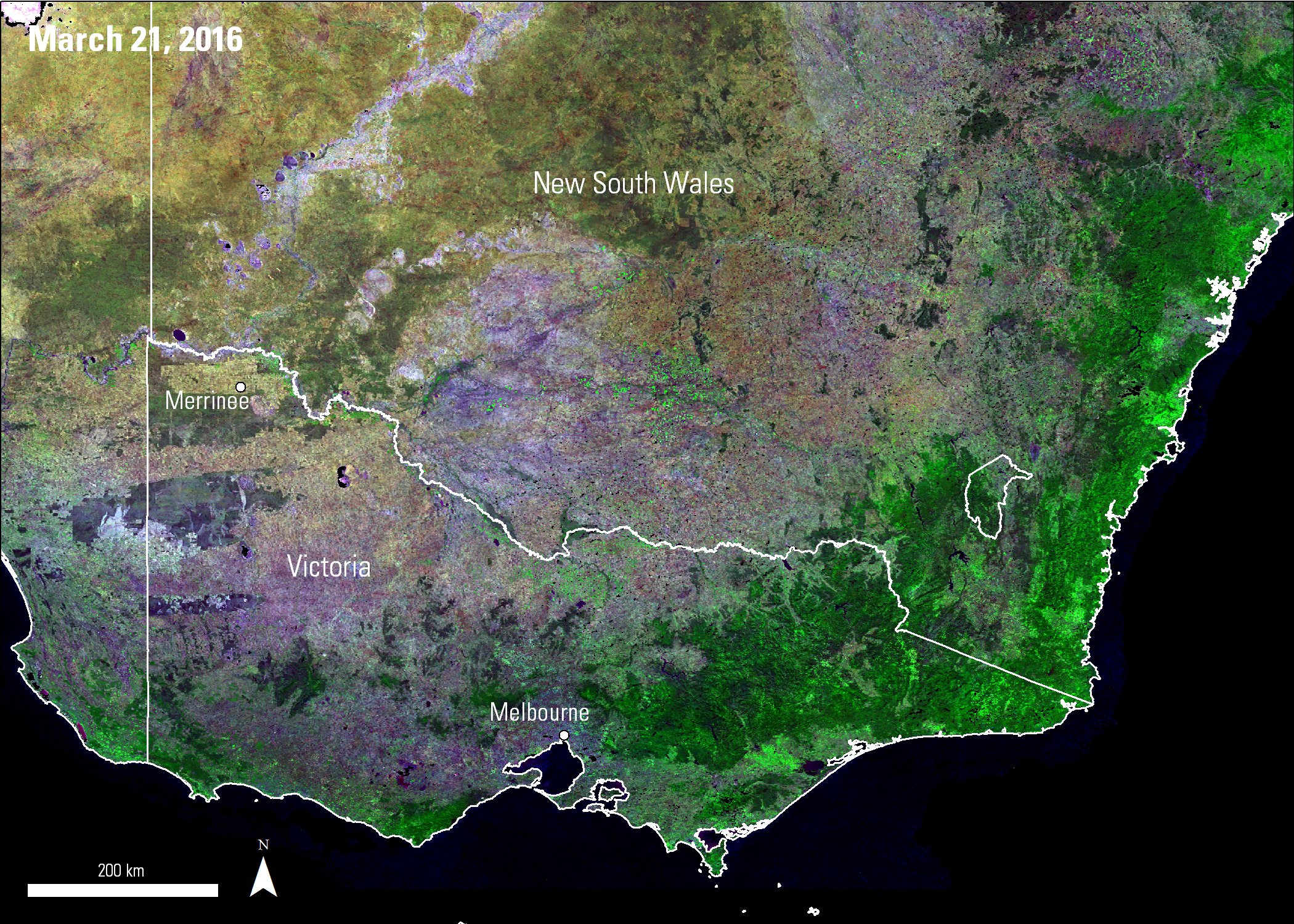
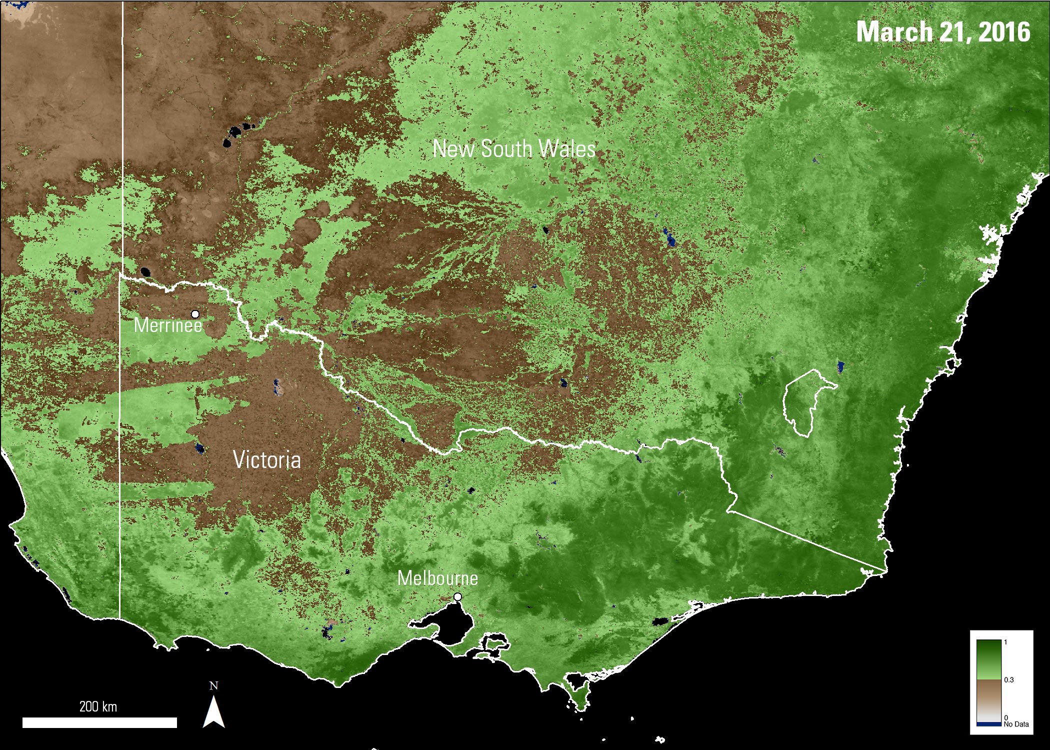
The left image shows a composite of the isometric parameter from BRDF/Albedo Parameters Bands 1, 2, and 3 from the Version 6 MCD43A1 data product, which is used to understand vegetation cover. Shades of green in the left image represent areas with green vegetation and rough surfaces, whereas purple and brown colors represent dry, desert areas with flat surfaces. Areas with less vegetation and flat surfaces are located in the upper left portion of this study area and near Merrinee, where vegetation has been “clear-cut”. Both areas are vulnerable to wind erosion. The right image shows MODIS NDVI from the MOD13A1 data product, where high data values (shades of green) indicate areas with healthier, greener vegetation.
Data information:
MCD43A1, Version 6: March 21, 2016; h28v12, h29v11, h29v12, h30v11, h30v12, h31v11, h31v12
MOD13A1, Version 6: March 21, 2016; h28v12, h29v11, h29v12, h30v11, h30v12, h31v11, h31v12
References:
Chappell, A, Webb, N.P., Guerschman, J.P., Thomas D.T., Mata G., Handcock R.N., Leys, J.F., and Butler H.J., 2017, Improving ground cover monitoring for wind erosion assessment using MODIS BRDF parameters: Remote Sensing of Environment, at https://doi.org/10.1016/j.rse.2017.09.026
Li, F., Jupp D.L.B, Paget, M., Briggs, P.R, Thankappan, M., Lewis, A., Held, A., 2017, Improving BRDF normalization for Landsat data using statistical relationships between MODIS BRDF shape and vegetation structure in the Australian continent: Remote Sensing of Environment, v.195, p.275-296, at https://doi.org/10.1016/j.rse.2017.03.032.
Sun, Q., Wang, Z., Li, Zhan, Erb, A., Schaaf, C.B., 2017, Evaluation of the global MODIS 30 arc-second spatially and temporally complete snow free land surface Albedo and reflectance anisotropy dataset: International Journal of Applied Earth Observation and Geoinformation, v.58, p.36-49, at: https://doi.org/10.1016/j.jag.2017.01.011.
University of Massachusetts Boston, 2017, BRDF Explained, accessed November 1, 2017 at: https://www.umb.edu/spectralmass/terra_aqua_modis/modis.
Material written by Cory Alden1
1 Innovate!, Inc., contractor to the U.S. Geological Survey, Earth Resources Observation and Science (EROS) Center, Sioux Falls, South Dakota, USA. Work performed under USGS contract G15PC00012 for LP DAAC2.
2 LP DAAC Work performed under NASA contract G15PD00467.