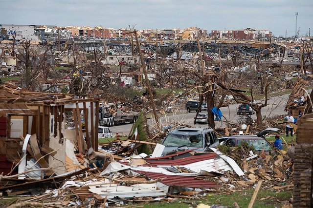
The destruction from the Joplin Tornado was captured by a member of the Ozarks Red Cross a few days after the tornado hit the town.
The destruction from the Joplin Tornado was captured by a member of the Ozarks Red Cross a few days after the tornado hit the town.
Approximately 1,200 tornados hit the United States every year. Tornados most frequently occur between March and July, with May being the most active month. This year marks the five-year anniversary of a particularly intense tornado season that produced 1,691 tornados. The deadliest and costliest tornado in the United States’ modern history struck Joplin, Missouri during this season. The tornado track, the damage it caused, and the recovery that has occurred since has been captured by Terra’s Advanced Spaceborne Thermal Emission and Reflection Radiometer (ASTER).
On May 22, 2011, a supercell thunderstorm in Joplin produced an EF-5 tornado with wind speeds faster than 320 kilometers (200 miles) per hour. While most tornados are barely on the ground longer than 10 minutes, this tornado lasted for a total of 38 minutes. In that time, the tornado covered 35.6 kilometers (22.1 miles), and in some areas reached 1.6 kilometers (1 mile) in width. The tornado claimed the lives of 158 people, injured over 1,150 others, and caused $2.8 billion in damage. The tornado damaged 30 percent of the city, destroying or severely damaging 7,000 homes, 500 businesses, half of the school district, and the St. John’s Regional Medical Center hospital. A total of approximately 2.3 million cubic meters (3 million cubic yards) of residential debris was produced. Click through the ASTER Level 1 Precision Terrain Corrected Registered At-Sensor Radiance (AST_L1T) images below to examine the area before the tornado, after the tornado, and what the area and tornado scar look like five years later.
ASTER’s visible and near-infrared data have 15-meter spatial resolution that can be used to detect a tornado’s path and determine the extent of damage; elements of a tornado that may not be recognizable from ground-level surveys.
Five years after the tornado, recovery efforts are still taking place in Joplin. There are 22 funds that were started to help the town and citizens recover from the tornado and for future major disasters. Within the first year of the tornado, Joplin received $39 million for recovery efforts. As of 2014, 90 percent of the homes and businesses that were destroyed by the tornado were replaced. Some of the structures that were rebuilt after the tornado, including the new Franklin Technology Center and the new Joplin High School can be seen in the April 9, 2016, ASTER image below.

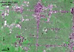
In this image you can see the city as it stood a few weeks before the tornado hit.
Granule ID:
AST_L1T_00305072011171220_20150605205101_76316
Approximately 7 kilometers (4.3 miles) of the tornado track is visible in this image.
Granule ID:
AST_L1T_00305302011171813_20150629104908_62389
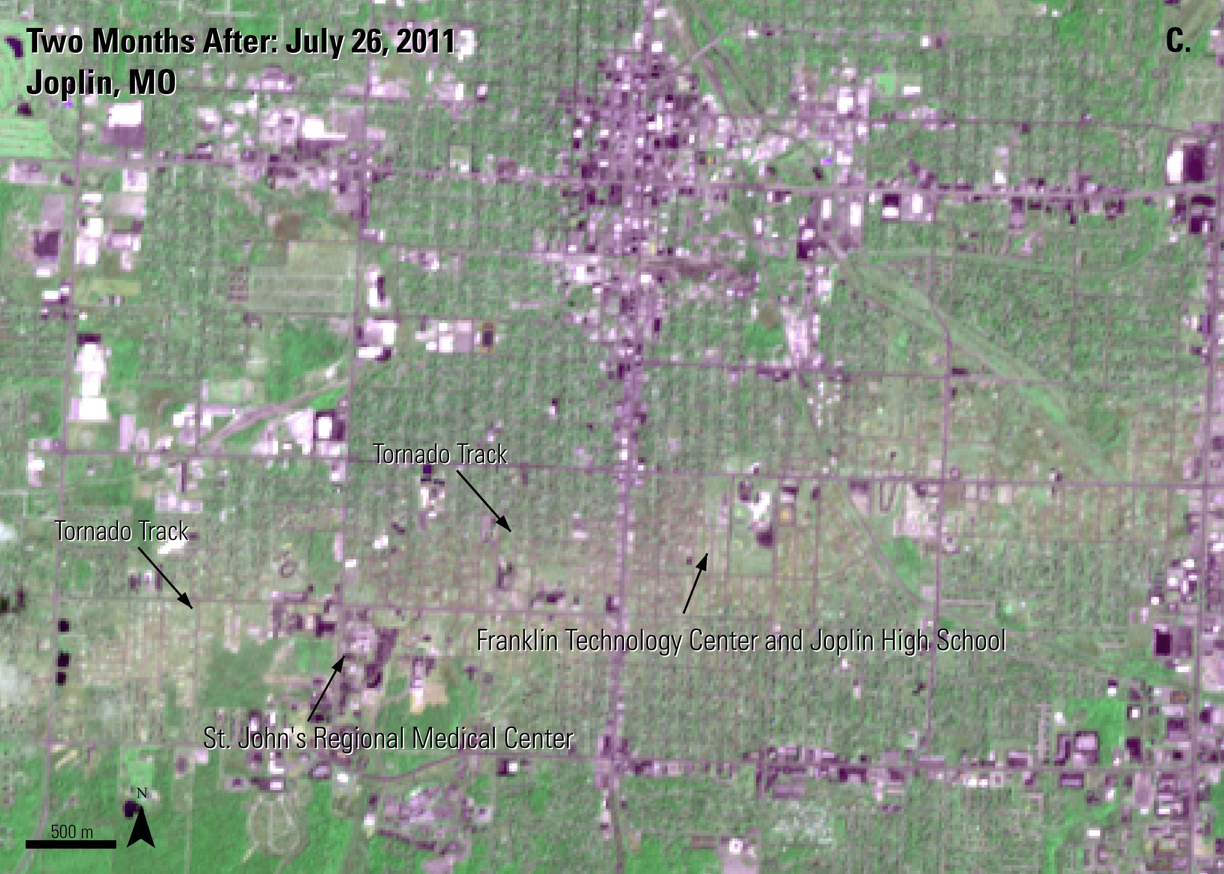
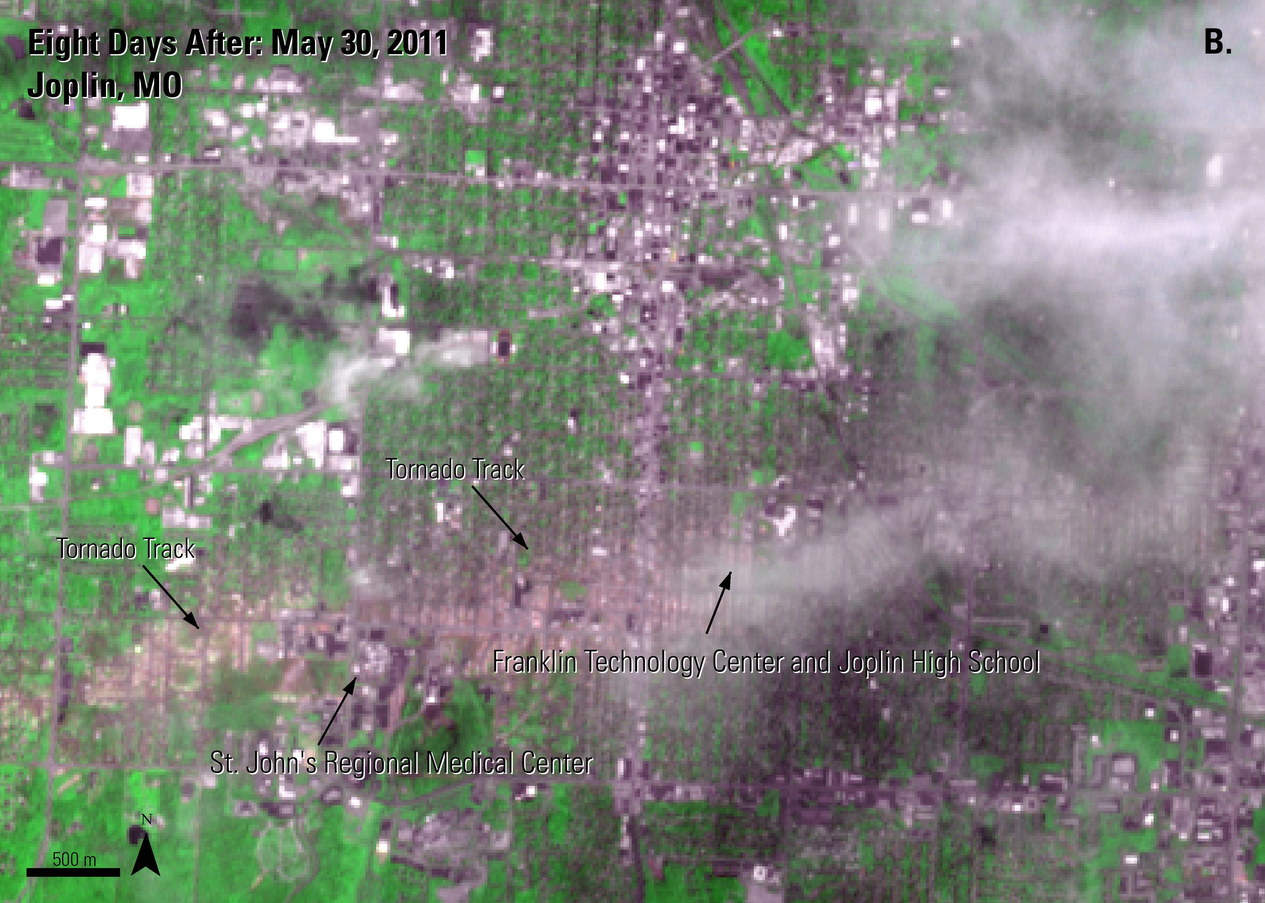
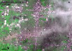
The tornado scar is still visible two months after the tornado. In this image you can also see some of the damaged structures in the area, including the St. John’s Regional Medical Center, the Franklin Technology Center, and Joplin High School.
Granule ID:
AST_L1T_00307262011171215_20150606224203_18784
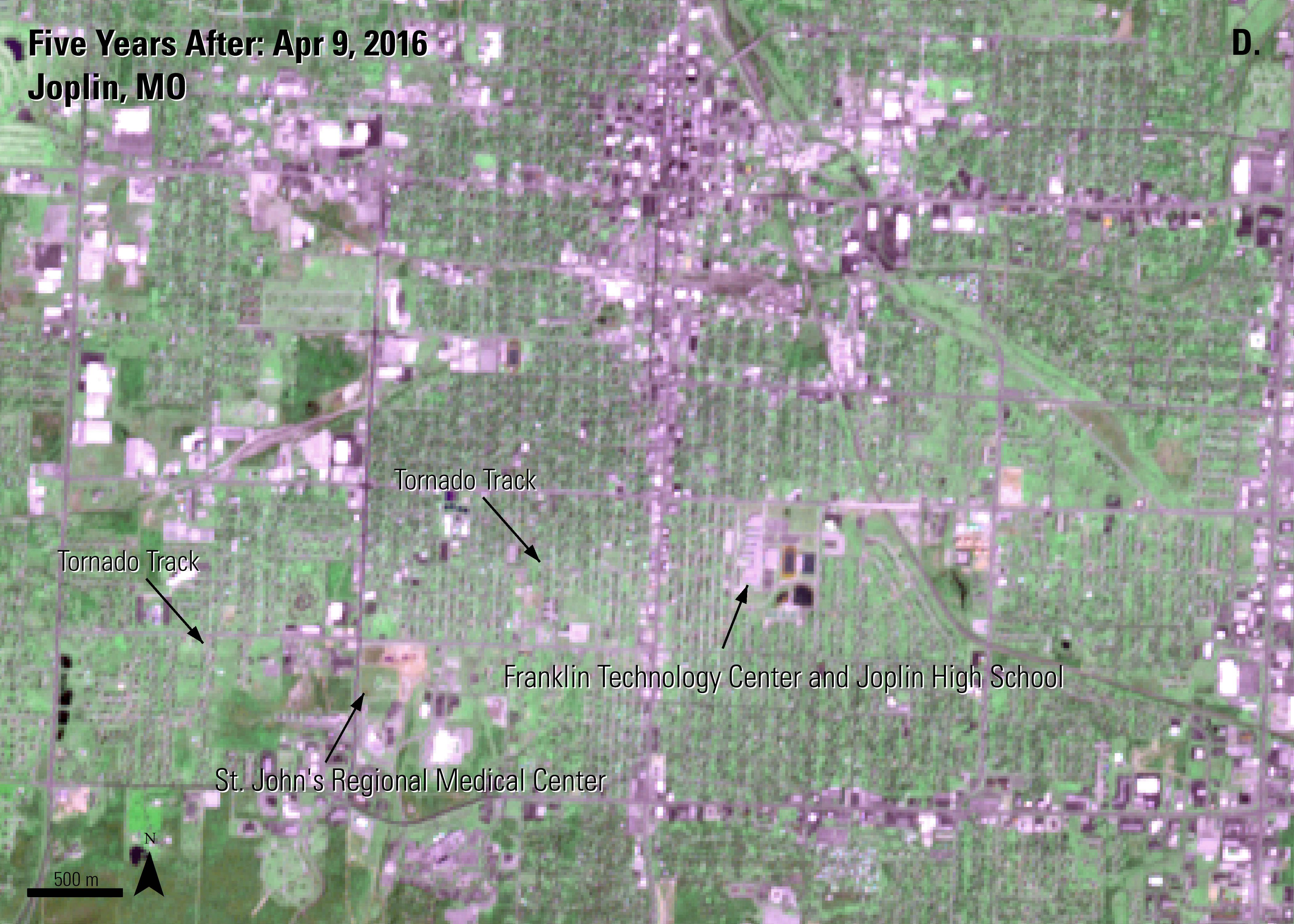
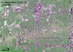
Five years after the tornado the scar is still slightly visible in the green vegetation. The site of the damaged St. John’s Regional Medical Center is now visibly bare after the hospital was declared structurally unsafe and demolished. The new Franklin Technology Center and Joplin High School schools are also visible in this image. They were built to replace the previous schools that were destroyed by the tornado.
Granule ID:
AST_L1T_00304092016171834_20160413144228_11249
In this image you can see the city as it stood a few weeks before the tornado hit.
Granule ID:
AST_L1T_00305072011171220_20150605205101_76316
Approximately 7 kilometers (4.3 miles) of the tornado track is visible in this image.
Granule ID:
AST_L1T_00305302011171813_20150629104908_62389
The tornado scar is still visible two months after the tornado. In this image you can also see some of the damaged structures in the area, including the St. John’s Regional Medical Center, the Franklin Technology Center, and Joplin High School.
Granule ID:
AST_L1T_00307262011171215_20150606224203_18784
Five years after the tornado the scar is still slightly visible in the green vegetation. The site of the damaged St. John’s Regional Medical Center is now visibly bare after the hospital was declared structurally unsafe and demolished. The new Franklin Technology Center and Joplin High School schools are also visible in this image. They were built to replace the previous schools that were destroyed by the tornado.
Granule ID:
AST_L1T_00304092016171834_20160413144228_11249

References: (Author's Note 5/15/2020: At the time of publishing these references were available online, some resources may no longer be available.)
American Geosciences Institute., 2015, Case Study: Remote Sensing Supports Emergency Management Response to Tornados, accessed May 9, 2016, at http://www.americangeosciences.org/critical-issues/case-study/remote-sensing-supports-emergency-management-response.
Huffington Post, 2014, New schools to open in Joplin, Missouri, after tornado, accessed May 10, 2016, at http://www.huffingtonpost.com/2014/01/05/joplin-missouri-new-schools_n_4545302.html.
Jedlovec, G., Nair, U., and Haines, S., 2006, Detection of Storm Damage Tracks with EOS Data: Weather and Forecasting, v. 21, accessed May 9, 2016, at http://dx.doi.org/10.1175/WAF923.1.
National Aeronautics and Space Administration, 2011, ASTER sees path of destruction from Joplin, Mo. tornado, accessed May 10, 2016, at http://www.jpl.nasa.gov/spaceimages/details.php?id=pia14174.
National Aeronautics and Space Administration, 2012, 2011 tornado information, accessed May 10, 2016, at http://www.noaanews.noaa.gov/2011_tornado_information.html.
National Oceanic and Atmospheric Administration, 2014, Joplin tornado – May 22nd, 2011, accessed May 10, 2016, at http://www.weather.gov/sgf/events_2011may22.
National Oceanic and Atmospheric Administration, 2014, Storm Events Database, accessed May 10, 2016, at http://www.ncdc.noaa.gov/stormevents/eventdetails.jsp?id=296617.
National Oceanic and Atmospheric Administration, 2016, The online tornado faq, accessed May 5, 2016, at http://www.spc.noaa.gov/faq/tornado/index.html.
Public Broadcasting Service, 2012, A year after Joplin’s tornado, disaster’s ‘immensity’ still a challenge, accessed May 10, 2016 at http://www.pbs.org/newshour/bb/science-jan-june12-joplin_05-22/.
The Joplin Globe, 2012, About $39 million given to major funds for Joplin’s storm recovery, accessed May 10, 2016 at http://www.joplinglobe.com/news/local_news/about-million-given-to-major-funds-for-joplin-s-storm/article_d5d1de78-b309-5b95-a354-6e4d0198608c.html.
The Joplin Globe, 2014, Rebuild Joplin wraps up mission with 180th home, accessed May 10, 2016 at http://www.joplinglobe.com/news/rebuild-joplin-wraps-up-mission-with-th-home/article_9400e75c-7ca1-11e4-9141-a3ac187792a3.html.
U.S. Department of Commerce, 2011, NWS Central Region Service Assessment Joplin, Missouri, Tornado – May 22, 2011, accessed May 10, 2016, at http://www.nws.noaa.gov/os/assessments/pdfs/Joplin_tornado.pdf.
Material written by Danielle Golon1
1 Innovate!, Inc., contractor to the U.S. Geological Survey, Earth Resources Observation and Science (EROS) Center, Sioux Falls, South Dakota, USA. Work performed under USGS contract G15PD00766 for LP DAAC2.
2 LP DAAC Work performed under NASA contract NNG14HH33I.