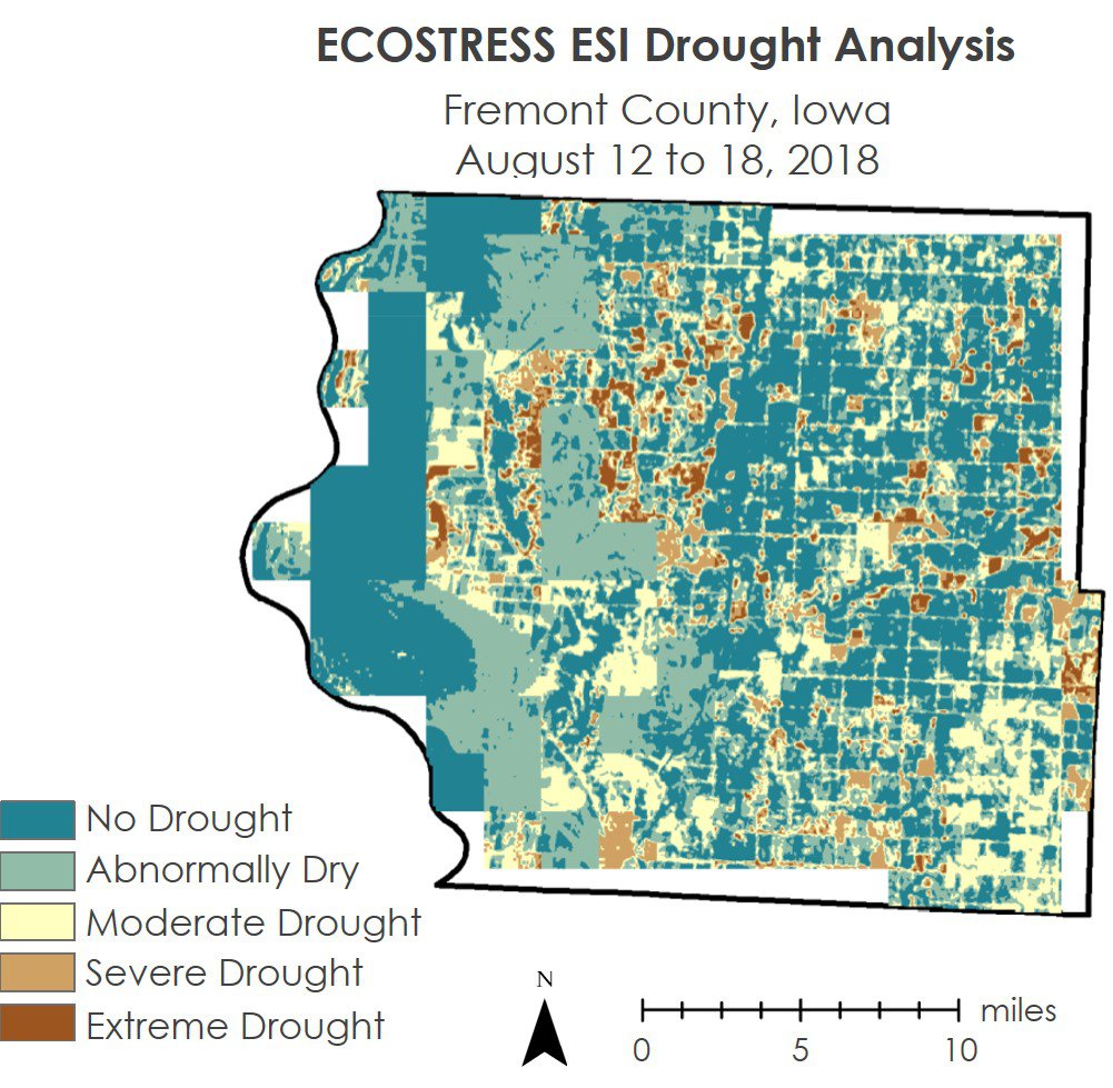
An ECOSTRESS-based Evaporative Stress Index (ESI) drought assessment map for Fremont County, Iowa, one week before peak drought created by the DEVELOP team. Brown areas on this image indicates areas of extreme drought.
Image courtesy of the Iowa Agriculture & Food Security Team.
An ECOSTRESS-based Evaporative Stress Index (ESI) drought assessment map for Fremont County, Iowa, one week before peak drought created by the DEVELOP team. Brown areas on this image indicates areas of extreme drought.
Image courtesy of the Iowa Agriculture & Food Security Team.
During the spring 2019 term of NASA’s DEVELOP National Program, participants used geospatial data and technologies to investigate, analyze, and monitor several issues around the world. Some of the topics explored throughout the term included agriculture, biodiversity, invasive species, changing ecologies, fire, natural disasters, water resources, and urbanization. Each project completed by a DEVELOP team is conducted in partnership with agencies or organizations local to the study area. Fundamental to the analytical and geospatial component of each of these projects is NASA Earth science remote sensing data. Several of these projects used data distributed by the Land Processes Distributed Active Archive Center, including data collected by the Advanced Spaceborne Thermal Emission and Reflection Radiometer (ASTER) sensor aboard NASA’s Terra satellite, the Moderate Resolution Imaging Spectroradiometer (MODIS) sensor aboard NASA’s Terra and Aqua satellites, the Visible Infrared Imaging Radiometer Suite (VIIRS) sensor aboard the joint NASA/NOAA Suomi National Polar-orbiting Partnership (Suomi NPP) satellite, NASA’s Shuttle Radar Topography Mission (SRTM), which flew aboard the space shuttle Endeavour in 2000, and NASA’s ECOsystem Spaceborne Thermal Radiometer (ECOSTRESS) sensor aboard the International Space Station (ISS).
All projects conducted in the spring term, as well as in past terms, can be found in the DEVELOP archive.
Drought is a serious issue that impacts most of the world at one time or another. One US state, Iowa, is particularly vulnerable to the economic devastation that droughts can cause because 92 percent of its land is classified as agriculture, a large portion of which is rain-fed, or dependent on seasonal rainfall. Historically it has been difficult to identify drought until it is already impacting plants and crops in an area, but what if we could detect drought sooner? That is what the Iowa Agriculture & Food Security DEVELOP team aimed to do during their term. The team used remote sensing data, including Evaporative Stress Index (ESI) data (ECO4ESIALEXIU) from the ECOSTRESS sensor aboard the ISS, Land Surface Temperature and Emissivity Suomi NPP NASA VIIRS data (VNP21A1D), and thermal data from the Landsat 8 Thermal Infrared Sensor (TIRS) to investigate if these data can be used to detect droughts sooner, which could help land managers take action to prevent crop loss. The team completed a statewide drought analysis by processing and analyzing these data using Geographic Information System (GIS) software, leading them to create two unique drought assessment models. They then compared their assessments with existing methodologies to see if using their method could help enhance the drought analysis procedures currently used by the Iowa Department of Agriculture and Land Stewardship Climatology Bureau. The team found that the higher spatiotemporal resolution ESI products they created can provide finer details for drought conditions. In the future, the Bureau will be able to use the assessments created by this DEVELOP team to enhance their current methods for tracking droughts.
Watch this video created by the Iowa Agriculture & Food Security DEVELOP team to learn more about their project and how they used NASA Earth science remote sensing data.
About the NASA DEVELOP National Program
The DEVELOP National Program is part of NASA’s Applied Sciences Program. Participants from around the country join the DEVELOP program for 10-week terms to apply data acquired by NASA Earth-observing satellites to bridge the gap between science and society. DEVELOP participants work with non-profit, local, state, and federal partners to create maps and other products in eight focus areas, including Food Security & Agriculture, Disasters, Ecological Forecasting, Energy, Health and Air Quality, Urban Development, Water Resources, and Transportation & Infrastructure.
Any use of trade, firm, or product names is for descriptive purposes only and does not imply endorsement by the U.S. Government.
References
Greene, B., Beatty, A., and Whiteside, A., 2019, Iowa Agriculture & Food Security—Assessing drought-induced vegetation stress and its impact on crop production across Iowa: NASA DEVELOP National Program web page, accessed February 5, 2020, at https://develop.larc.nasa.gov/2019/spring/IowaAg.html.
NASA DEVELOP National Program, 2019, Take a rain check—Monitoring drought conditions in Iowa: NASA DEVELOP National Program video, 00:02:04, posted April 5, 2019, accessed February 5, 2020, at https://www.youtube.com/watch?v=FfGjEDCAvso.
Written by: Danielle Golon1, Brittany Greene3, Audrieauna Beatty3, Abigail Whiteside3, Amanda Clayton4
1 Innovate!, Inc., contractor to the U.S. Geological Survey, Earth Resources Observation and Science (EROS) Center, Sioux Falls, South Dakota, USA. Work performed under USGS contract G15PC00012 for LP DAAC2.
2 LP DAAC work performed under NASA contract NNG14HH33I.
3 SSAI, NASA DEVELOP National Program5, NASA Marshall Space Flight Center, Huntsville, Alabama, USA.
4 SSAI, NASA DEVELOP National Program5, Langley Research Center, Hampton, Virginia, USA.
5 SSAI NASA DEVELOP work performed under NASA contract NNL16AA05C