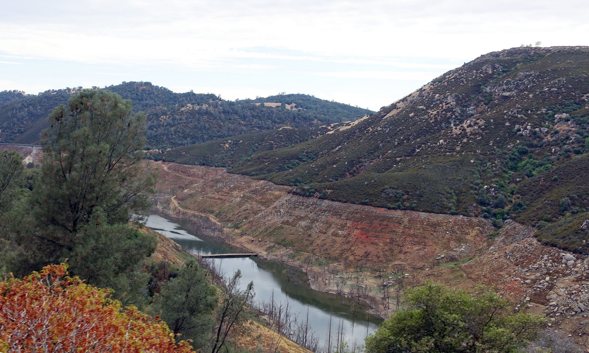
New Melones Lake captured on June 28, 2015. This reservoir is located in the Sierra Nevada foothills. According to the state of California, the reservoir was at 17 percent of total capacity when this photo was taken.
Image credit: Stuart Rankin / flickr.com / CC by SA 2.0
New Melones Lake captured on June 28, 2015. This reservoir is located in the Sierra Nevada foothills. According to the state of California, the reservoir was at 17 percent of total capacity when this photo was taken.
Image credit: Stuart Rankin / flickr.com / CC by SA 2.0
The state of California is in its fourth consecutive year of drought, according to the California Department of Water Resources. This drought has been amplified by increasing temperatures in the region, which impacts water in the state in many ways. The main sources of consumable and agricultural water for California are underground aquifers, reservoirs, and mountain snowpacks. However, in recent years the volume of water in these sources has been, and is currently, decreasing.
There are many factors that are contributing to the current drought in California. One of the contributing factors is a record decrease in the amount of snowfall during recent winters. Typically snowfall accumulates during the winter, forming snowpacks, which melt during the spring. This meltwater flows into streams, reservoirs, and rivers. According to Carlson and others (2015) peak snowpacks are traditionally measured in California both manually and electronically every year on April 1. During years of normal precipitation, the California Department of Water Resources records melted snowpack as providing approximately 30 percent of California’s water supply. However, the recent amount of snowfall has limited this source of water.
The Moderate Resolution Imaging Spectroradiometer (MODIS) sensor, located on NASA’s Terra and Aqua satellites, is able to provide daily coverage of the Earth. These satellite data can be used to observe how large areas of the Earth’s landscapes change over time, including changes in snowpack. Below, surface reflectance data from Terra MODIS (MOD09GA) illustrates changes in the snowpack of the Sierra Nevada Mountain range from 2006 to 2015. Wet years are typically characterized by larger snowpacks and drought years by lesser snowpacks. The state of California identified 2006, 2010, and 2011 as wet years and drought years as 2007 – 2009 and 2012 – 2015.
According to the United States Department of Agriculture’s Natural Resources Conservation Service, during the initial months of 2015 the snow water equivalent (SWE) was at a maximum of only 50 percent of the average SWE during these months. The 2015 measurements recorded a high of 31 percent of the average SWE for April. According to Belmecheri and others (2015) the SWE in the Sierra Nevada Mountains was at 5 percent of its historical average. By looking at blue oak tree-ring data, Belmecheri and others determined that based on 500 years of data, the 2015 SWE for the Sierra Nevada Mountains is at an unprecedented low.
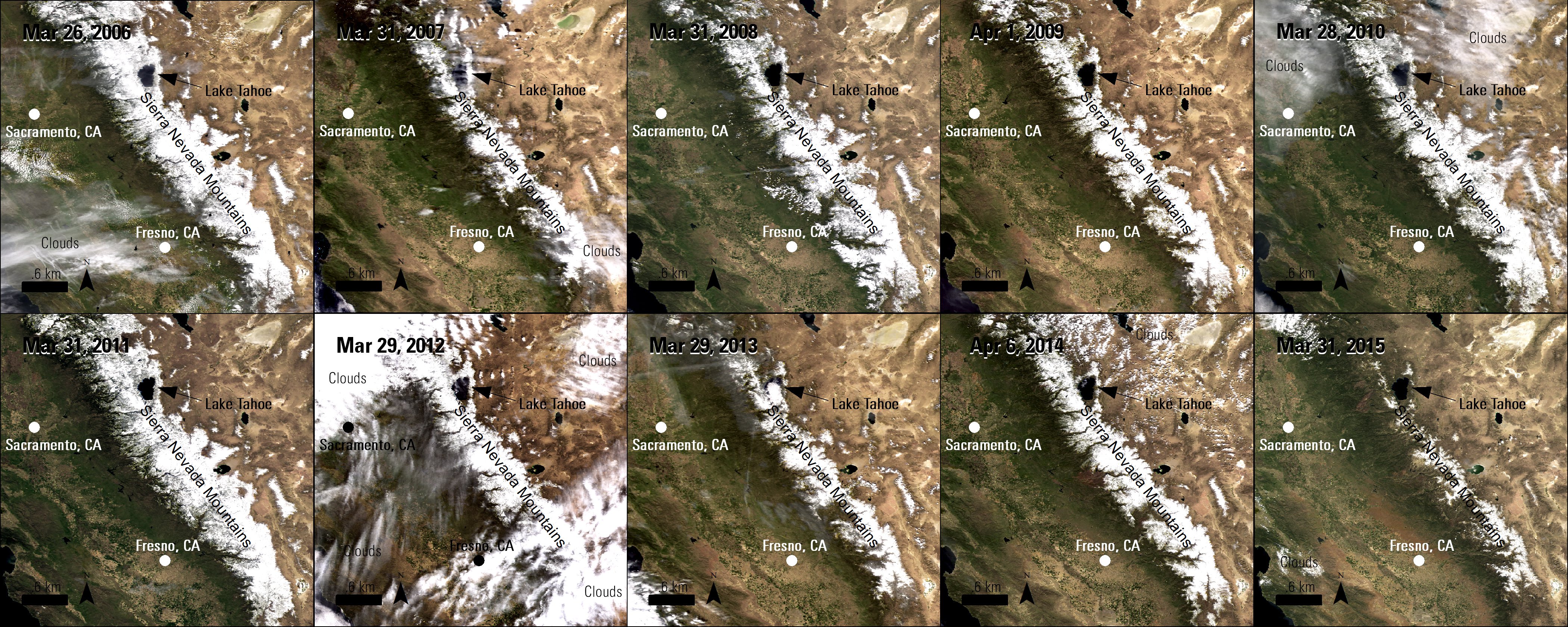
Ten Terra MODIS true-color surface reflectance (MOD09GA) images of the Sierra Nevada Mountains captured between 2006 and 2015 during the end of March and the beginning of April. Researchers can use MODIS surface reflectance data to observe and measure changes in snow levels.
Granule IDs:
MOD09GA.A2006085.h08v04.005.2008085173123
MOD09GA.A2006085.h08v05.005.2008085162715
MOD09GA.A2007090.h08v04.005.2007094102912
MOD09GA.A2007090.h08v05.005.2007094101645
MOD09GA.A2008091.h08v04.005.2008093175250
MOD09GA.A2008091.h08v05.005.2008093191619
MOD09GA.A2009091.h08v04.005.2009094000208
MOD09GA.A2009091.h08v05.005.2009094003604
MOD09GA.A2010087.h08v04.005.2010089160905
MOD09GA.A2010087.h08v05.005.2010089163601
MOD09GA.A2011090.h08v04.005.2011094201431
MOD09GA.A2011090.h08v05.005.2011094203321
MOD09GA.A2012089.h08v04.005.2012093192229
MOD09GA.A2012089.h08v05.005.2012093192234
MOD09GA.A2013088.h08v04.005.2013090083213
MOD09GA.A2013088.h08v05.005.2013090083135
MOD09GA.A2014096.h08v04.005.2014098060732
MOD09GA.A2014096.h08v05.005.2014098060512
References: (Author's Note 5/15/2020: At the time of publishing these references were available online, some resources may no longer be available.)
Belmercheri, S., Babst, F., Wahl, E.R,. Stahle, D.W., and Trouet, V., 2015, Multi-century evaluation of Sierra Nevada snowpack: Nature Climate Change, September 14, 2015, accessed September 16, 2015, at http://www.nature.com/nclimate/journal/vaop/ncurrent/full/nclimate2809.html.
Brice, A., 2015, Is drought killing California’s giant sequoias?: Berkeley Research News, August 6, 2015, accessed August 18, 2015, at http://vcresearch.berkeley.edu/news/drought-killing-californias-giant-sequoias.
California Department of Water Resources, 2015, California’s most significant droughts: Comparing historical and recent conditions, accessed September 11, 2015, at http://www.water.ca.gov/waterconditions/docs/California_Signficant_Droughts_2015_small.pdf.
Carlson, D., Scott, E., and Macias, M., 2015, Sierra Nevada snowpack is virtually gone; Water content now is only 5 percent of historic average, lowest since 1950: California Department of Water Resources News Release, April 1, 2015, accessed September 11, 2015, at http://www.water.ca.gov/news/newsreleases/2015/040115snowsurvey.pdf.
State of California, 2015, New Melones – Storage conditions as of June 28, 2015: California Data Exchange Center, accessed September 15, 2015, at http://cdec.water.ca.gov/cdecapp/resapp/resDetailOrig.action?resid=NML.
State of California, 2015, Top story: California state climatologist: Do not count on El Niño to end drought: State of California Web page, accessed August 18, 2015, at http://ca.gov/drought/topstory/top-story-45.html.
Natural Resources Conservation Service, 2015, Snow water equivalent percent of official median [map], accessed September 11, 2015, at http://www.wcc.nrcs.usda.gov.
U.S. Geological Survey, 2015, The California drought: California Water Science Center Web page, accessed September 4, 2015, at http://ca.water.usgs.gov/data/drought/drought-impact.html.
U.S. Geological Survey, 2015, Snowmelt – The water cycle: The Water Cycle – USGS Water Science School Web page, accessed September 11, 2015, at http://water.usgs.gov/edu/watercyclesnowmelt.html.
Material written by Danielle Golon1
1 Innovate!, Inc., contractor to the U.S. Geological Survey, Earth Resources Observation and Science (EROS) Center, Sioux Falls, South Dakota, USA. Work performed under USGS contract G15PD00766 for LP DAAC2.
2 LP DAAC Work performed under NASA contract NNG14HH33I.