(Author's Note 2/28/2022: At the time of publishing these references were available online, some resources may no longer be available.)
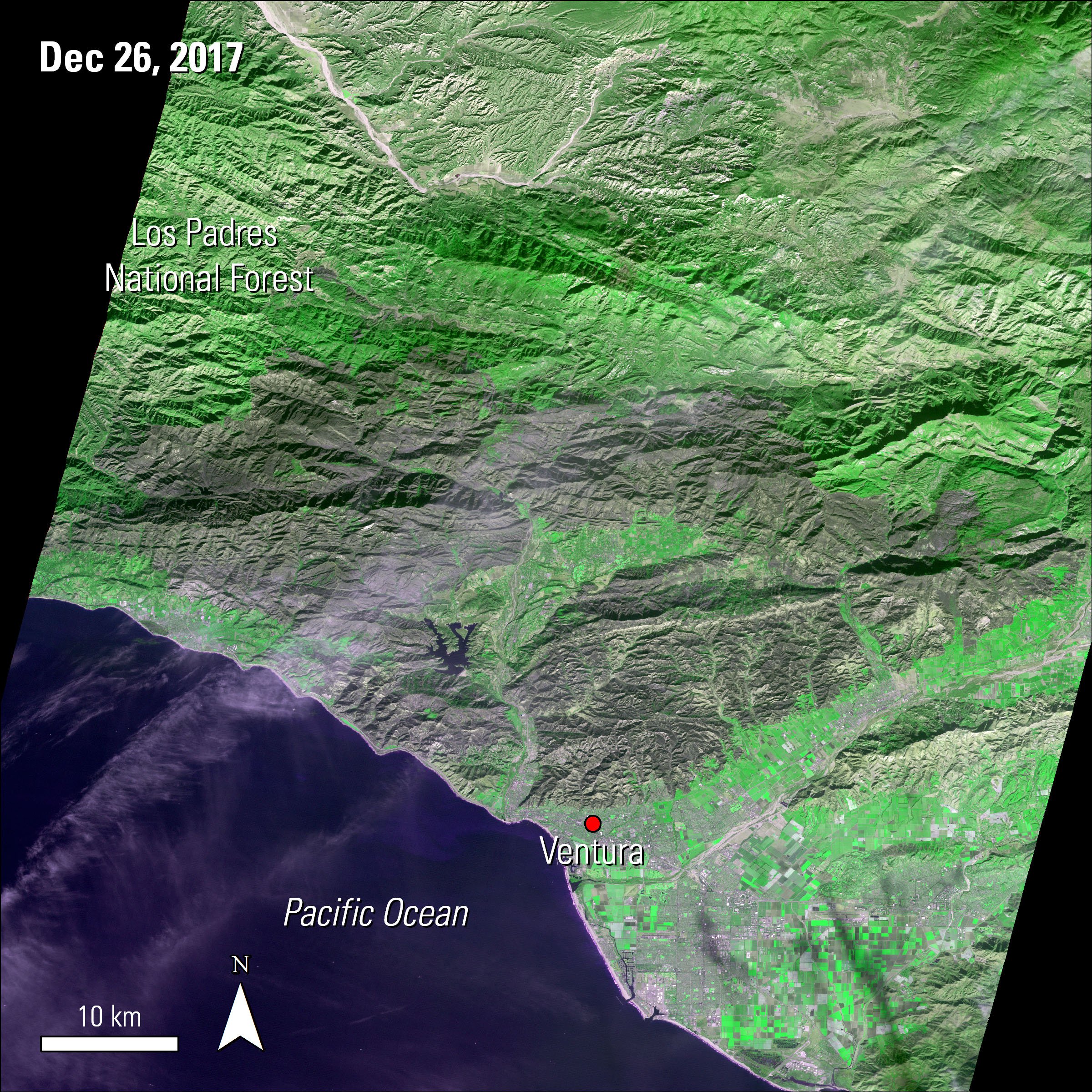
A view of part of the burn scar from the Thomas Fire in Ventura and Santa Barbara counties, California, using data from the Terra ASTER satellite sensor. Using the 2-3-1 band combination, the burn scar is shown as a dark color amid the healthier green vegetation.
Granule IDs:
AST_L1T_00312262017184602_20171227105143_14300
AST_L1T_00312262017184553_20171227105133_12674
DOI:
10.5067/ASTER/AST_L1T.003
(Author's Note 3/1/2024: At the time of publishing these references were available online, some resources may no longer be available.)
In December 2017, California experienced the Thomas Fire, the largest wildfire since the Santiago Canyon Fire of 1889. The fire ignited on December 4, 2017, burning approximately 1,141 square kilometers (sq km) (282,000 acres) of land. The fire destroyed 1,063 structures and damaged another 280 as of January 11, when the fire was 92 percent contained. A Terra Advanced Spaceborne Thermal Emission and Reflection Radiometer (ASTER) image (AST_L1T) of the burn scar from the fire, covering both Ventura and Santa Barbara counties, is shown on the right.
Heavy rainfall in January brought relief from the fires, but also brought a new risk for mudslides and floods in areas impacted by the Thomas Fire.
Using Surface Reflectance data from the National Aeronautics and Space Administration’s (NASA) Earth science satellites, progression of the Thomas Fire can be observed with a sky-eye view throughout the month of December. The animation loop below uses daily Surface Reflectance data from NASA’s Terra and Aqua Moderate Resolution Imaging Spectroradiometer (MODIS) and the joint NASA/National Oceanic and Atmospheric Administration (NOAA) Suomi National Polar-orbiting Partnership (Suomi NPP) Visible Infrared Imaging Radiometer Suite (VIIRS) satellite sensors. The Terra MODIS sensor provides daily morning coverage with the 500 meter (m) and 1 km product (MOD09GA). The Aqua MODIS sensor provides daily afternoon coverage with the 500 m and 1 km product (MYD09GA). The Suomi NPP VIIRS satellite sensor also provides afternoon coverage with the 500 m and 1 km product (VNP09GA). These three sources allowed for consistent fire coverage throughout each day during the month.
Imagery of the Thomas Fire from December 2017. The imagery was created using Surface Reflectance data from the Suomi NPP NASA VIIRS images using a band combination of I3-I2-I1, which highlights the natural colors in the Surface Reflectance image. The Terra and Aqua MODIS images use a band combination of 7-2-1, highlighting burn scars and fires in the area.
Data Information:
VNP09GA (10.5067/VIIRS/VNP09GA.001): December 3, 6, 8, 10, 13, 14, 25, and 28, 2017
MOD09GA (10.5067/MODIS/MOD09GA.006): December 12, 15, 17, 19, 20, 21, 22, 24, 26, 29, 30, 31, 2017
MYD09GA (10.5067/MODIS/MYD09GA.006): December 4, 5, 7, 9, 11, 16, 18, 23, 27, 2017
For more information on MODIS and VIIRS Surface Reflectance data, please watch the following YouTube videos:
Getting Started with VIIRS Surface Reflectance Data
Getting Started with MODIS Version 6 Surface Reflectance Data
References: (Author's Note 2/28/2022: At the time of publishing these references were available online, some resources may no longer be available.)
CalFire, 2018, Top 20 largest California wildfires: State of California web page, accessed January 11, 2018, at http://www.fire.ca.gov/communications/downloads/fact_sheets/Top20_Acres.pdf.
InciWeb, 2018, Thomas Fire: National Wildfire Coordinating Group web page, accessed January 5, 2018, at https://inciweb.nwcg.gov/incident/5670/.
Vercammen, P., 2018, Mudslide danger replaces fire threat in Southern California: KEYT News, January 2, 2018, accessed January 5, 2018, at http://www.keyt.com/news/national-world/mudslide-danger-replaces-fire-threat-in-southern-california/680412493.
Mejia, B., 2017, Thomas Fire could become largest on record in California: Los Angeles Times, December 16, 2017, accessed January 10, 2018, at http://www.latimes.com/local/california/la-me-ln-thomas-fire-historical-20171215-story.html.
Los Padres National Forest [@LosPadresNF], 2018, Areas that may not have been flood- or slide-prone previously may now be at risk. Flood preparation information is available at http://www.countyofsb.org/pwd/floodprep.sbc …,
Los Padres National Forest tweet, January 3, 2018, accessed January 5, 2018, at https://twitter.com/LosPadresNF/status/948650919909978112.
U.S. Forest Service, 2018, Thomas Fire update: U.S. Forest Service news release, January 10, 2018, accessed January 10, 2018, at http://mailchi.mp/c6d805fcc4fd/los-padres-national-forest-post-fire-response-88695.
Material written by Danielle Golon1
1 Innovate!, Inc., contractor to the U.S. Geological Survey, Earth Resources Observation and Science (EROS) Center, Sioux Falls, South Dakota, USA. Work performed under USGS contract G15PD00467 for LP DAAC2.
2 LP DAAC work performed under NASA contract NNG14HH33I.