Terra ASTER
NCEP/TOVS data in processing ASTER Level 2 On-Demand products. Since April 18, 2005, the NOAA TIROS Operational Vertical Sounder (TOVS) data produced by the National Centers for Environmental Prediction (NCEP) have contained errors due to satellite instru…
Aqua MODIS Terra MODIS
Due to the non-availability of NOAA's ozone daily product, the forward production of the TERRA and AQUA surface reflectance and its downstream products is on hold. The surface reflectance code (PGE11) has been modified to use EPTOMS and/or NCEP'…
Terra ASTER
To obtain an estimate of the next opportunities for ASTER to image a location on Earth, enter the latitude and longitude for your location and then select Forecast Possible ASTER Collection Times. The information returned is based on output from the NASA …
The LP DAAC is pleased to announce the release of a new V004 data set:
MODIS/Terra Land Cover Types Yearly L3 Global 0.05Deg CMG -MOD12C1
- V003 Oct 15 2000 (2000289) - Oct 15 2001 (2001288)Validated Stage 1
- V004 2001 -Validated Stage 1
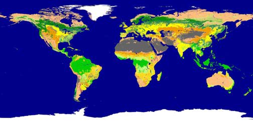
2001 image of MOD12C1 IG…
Data Pool
The Data Pool HDFEOS-to-GeoTiff (HEG) tool provides the ability to reformat, reproject, or spatially subset data available via the LP DAAC Data Pool. The Data Pool HEG services are completed prior to product distribution, and may be applied only to produc…
(Author's Note 2/24/2025: Users are encouraged to use NASA’s Earthdata Search to discover and download LP DAAC data products via HTTPS.)
________________________________________________________________________________________________
As of March 30, 20…
LDOPE
(Author's Note 5/18/2020: MRT, MRTSwath, and MODextract have since been retired. Data from the LP DAAC is now no longer available in GloVis. Users are encouraged to use NASA Earthdata Search or AppEEARS.)
On July 12, 2004, new releases have been made …
Terra MODIS
Terra MODIS V003 data will not be available as of March 31, 2004. The collection is undergoing maintenance associated with reprocessing. Version 003 products have been superceded by reprocessing to version 004.
Watch for the Golden Month of Terra V003 data…
As of March 31, 2004, Landsat 7 ETM+ data will no longer be available for search and order through the LP DAAC and the EOS Data Gateway (EDG). All orders submitted to the LP DAAC prior to this date will be filled, provided payment is received within a re…
LDOPE
The MODIS Land Data Operational Product Evaluation (LDOPE) software tools were developed by the MODIS LDOPE Team to assist with the analysis and quality assessment of the MODIS Land products.
MODIS LDOPE Tools are available at the LP DAAC Web site.
Data Pool Aqua MODIS Combined MODIS Terra ASTER Terra MODIS
The LP DAAC now has over forty terabytes of selected MODIS and ASTER products available quickly, on-line, and free of charge. Nearly 250,000 scenes of over fifty different product types are located on the LP DAAC's Data Pool, and are available throug…
Combined MODIS
MODIS/Terra+Aqua, or Combined, products are generated using a combination of Terra and Aqua acquisitions to optimize data quality. Current production includes only the BRDF and Albedo products; see the Products page of the LP DAAC Web site for more inform…
(Author's Note 5/19/2020: MRT Swath has since been retired. Users are encouraged to use NASA Earthdata Search as an alternative to MRT Swath.)
Welcome to the MODIS Swath Reprojection Tool (MRT Swath) distribution page. The Land Processes Distributed A…
Data Pool Aqua MODIS
The LP DAAC began removing the Aqua MODIS version 003 data products from the Data Pool starting January 29, 2004 in order to make space available for Aqua MODIS version 004 data products. Our plan is to reload the Data Pool with the Aqua MODIS version 004…