During the fall 2020 term of NASA’s DEVELOP National Program, participants used geospatial data and technologies to investigate, analyze, and monitor several issues around the world. Some of the topics explored throughout the term included agriculture, air quality, drought, ecosystems, energy, natural disasters, oceans, urban planning, water resources, and wildfires. Each project completed by a DEVELOP team is conducted in partnership with agencies or organizations local to the study area. Fundamental to the analytical and geospatial component of each of these projects is NASA Earth science remote sensing data. Several of these projects used data distributed by the Land Processes Distributed Active Archive Center, including data collected by the Moderate Resolution Imaging Spectroradiometer (MODIS) sensor aboard NASA’s Terra and Aqua satellites, the Visible Infrared Imaging Radiometer Suit (VIIRS) aboard the Suomi National Polar-Orbiting Partnership (Suomi NPP) satellite, NASA’s Shuttle Radar Topography Mission (SRTM), which flew aboard the space shuttle Endeavour in 2000, Global Ecosystem Dynamics Investigation (GEDI) aboard the International Space Station (ISS) and Ecosystem Spaceborne Thermal Radiometer Experiment on Space Station (ECOSTRESS) also aboard the ISS.
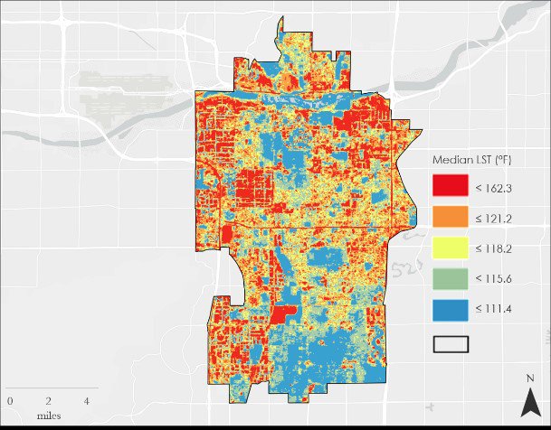
2015-2020 composite map of the median Land Surface Temperature (LST) for all warm season months in Tempe, Arizona derived from Landsat 8 OLI/TIRS. Areas in red illustrate the hottest areas in the city.
Image courtesy of the Tempe Urban Development II Team.
2015-2020 composite map of the median Land Surface Temperature (LST) for all warm season months in Tempe, Arizona derived from Landsat 8 OLI/TIRS. Areas in red illustrate the hottest areas in the city.
Image courtesy of the Tempe Urban Development II Team.
All projects conducted in the fall term, as well as in past terms, can be found in the DEVELOP archive.
One of the fall projects used NASA earth observation data to investigate drivers of urban heat. The southwestern United States is known for its semi-arid climate and hot temperatures. In Tempe, Arizona, temperatures are regularly above 37.8° C (100.0° F) during the summer. The area has seen an increase in surface and air temperatures as the city has urbanized and expanded its footprint. This has raised concerns from city and health officials in Tempe because Maricopa County has seen thousands of heat related hospitalizations and hundreds of heat related deaths over the past 15 years. The Tempe Urban Development II team set out to use NASA Earth science remote sensing data to investigate what is driving the temperature increases and identifying locations in the city that would benefit most from targeted heat mitigation and adaptation efforts. The project leveraged data from Aqua Moderate Resolution Imaging Spectroradiometer (MODIS), specifically the Nighttime Land Surface Temperature (LST) (MYD11A1) data product, and composite data derived from Landsat 8 Thermal Infrared Sensor (TIRS) and Landsat 8 Operational Land Imager (OLI) (e.g. NDVI, NDWI, and NDBI). These data, combined with ancillary census, bus stop, and Light Detection and Ranging (lidar) data, were used to make various heat exposure, vulnerability, and priority maps through a principal component analysis. They were also used to produce a geodatabase that can be used by the City of Tempe to make data driven decisions. Through their project, the team identified several areas in Tempe that would benefit most from heat relief mitigation. Identified areas included the Alegre Community, Dwight Park, the Escalante neighborhood, and University Heights. The results of this project were shared with the City of Tempe and may be used for future heat relief implementation strategies.
(Author’s Note: The NASA DEVELOP Team used Aqua MODIS version 6 data. The LP DAAC recently released Terra and Aqua MODIS version 6.1 data. The equivalent version 6.1 Aqua MODIS set used in this project can be found here: https://doi.org/10.5067/MODIS/MYD11A1.061.)
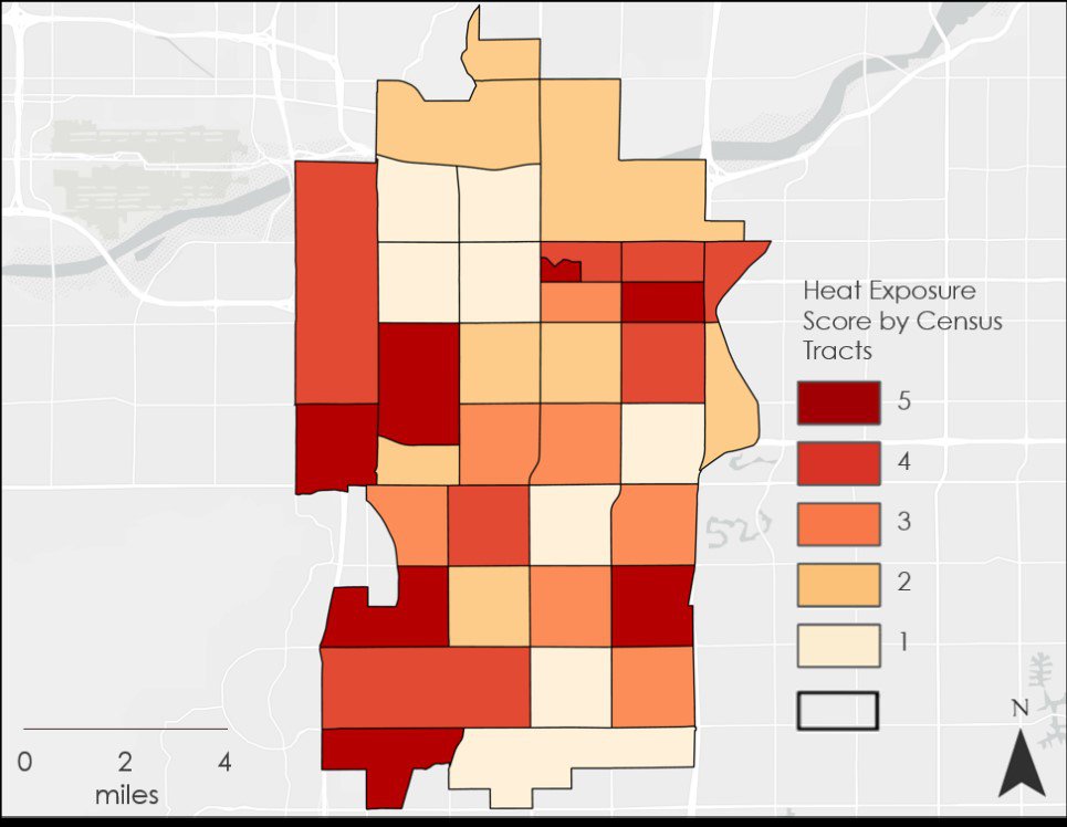
Heat Exposure Score (HES) by census tract map for Tempe, Arizona from 2015-2020. Principal components included biophysical variables derived from Landsat 8 and Aqua MODIS. Census tracts with a HES of 5 indicate a very high priority for future mitigation projects.
Heat Exposure Score (HES) by census tract map for Tempe, Arizona from 2015-2020. Principal components included biophysical variables derived from Landsat 8 and Aqua MODIS. Census tracts with a HES of 5 indicate a very high priority for future mitigation projects.
About the NASA DEVELOP National Program
The DEVELOP National Program is part of NASA’s Applied Sciences Program. Participants from around the country join the DEVELOP program for 10-week terms to apply data acquired by NASA Earth-observing satellites to bridge the gap between science and society. DEVELOP participants work with non-profit, local, state, and federal partners to create maps and other products in eight focus areas, including Food Security & Agriculture, Disasters, Ecological Forecasting, Energy, Health & Air Quality, Urban Development, Water Resources, and Transportation & Infrastructure.
Any use of trade, firm, or product names is for descriptive purposes only and does not imply endorsement by the U.S. Government.
References:
Boogaard, S., Dialesandro, J., Shun Anson Pang, Y., and Steiner, S., 2021, Tempe Urban Development II—Establishing an Urban Heat Exposure Severity Score for Infrastructure Prioritization in Tempe, Arizona, Using NASA Earth Observations and LiDAR: NASA DEVELOP National Program web page, accessed April 27, 2021, at https://develop.larc.nasa.gov/2020/fall/TempeUrbanDevII.html.
Written by Danielle Golon1, Sydney Boogaard3, John Dialesandro3, Yik Shun Anson Pang3, Blake Steiner3, Amanda Clayton4
1 C2G, contractor to the U.S. Geological Survey, Earth Resources Observation and Science (EROS) Center, Sioux Falls, South Dakota, USA. Work performed under USGS contract G0121D0001 for LP DAAC2.
2 LP DAAC work performed under NASA contract NNG14HH33I.
3 SSAI, NASA DEVELOP National Program5, Arizona State University, Tempe, Arizona, USA.
4 SSAI, NASA DEVELOP National Program5, Langley Research Center, Hampton, Virginia, USA.
5 SSAI NASA DEVELOP work performed under NASA contract NNL16AA05C