Table of Contents
Introduction
Visible Infrared Imaging Radiometer Suite (VIIRS) data products are developed by the National Aeronautics and Space Administration (NASA) and are distributed by NASA’s Land Processes Distributed Active Archive Center (LP DAAC).
VIIRS is aboard two satellites: NASA/NOAA Suomi National Polar-orbiting Partnership (Suomi NPP) and NOAA-20. Suomi NPP, which contains five instruments including VIIRS, was launched from Vandenberg Air Force Base on October 28, 2011. It was the first in a series of four Joint Polar Satellite System (JPSS) satellites, a collaborative mission between NOAA and NASA, that carries the VIIRS instrument. The second JPSS satellite, NOAA-20, was launched into space on November 18, 2017. It is the first spacecraft of NOAA's next generation of polar-orbiting satellites. NOAA-20 contains similar instruments as Suomi NPP including VIIRS. NOAA-20 circles the earth in the same orbit as Suomi NPP but is separated in time and space by 50 minutes, providing additional VIIRS coverage over previously captured areas by Suomi NPP, similar to how the Terra and Aqua satellites provide Moderate Resolution Imaging Spectroradiometer (MODIS) data.
VIIRS observes the entire Earth’s surface twice each day crossing equator approximately 14 times each day per satellite. Suomi NPP crosses the equator about 1:30 a.m. and 1:30 p.m. and NOAA-20 crossing at 2:20 am and 2:20 pm, local time; from NPP’s polar orbit 824 kilometers (km) (512 miles) above the Earth’s surface. The 3,000 km swath width of the VIIRS instrument, which is 710 km greater than that of MODIS, allows for no gaps in coverage as observed in MODIS near the equator. The VIIRS instrument provides 22 spectral bands from 412 nanometers (nm) to 12 micrometers (µm) at two spatial resolutions, 375 meters (m) and 750 m, which are resampled to 500 m, 1 km, and 0.05 degrees in the NASA produced data products to promote consistency with the MODIS heritage.
VIIRS Naming Conventions
VIIRS Filenames
VIIRS filenames for Level 2G, Level 3, and Level 4 products follow a naming convention which provides useful information regarding the specific product.
In this example for a swath product, the filename VJ121.A2021101.0054.002.2021102014936.nc indicates:
- VJ121: Product Short Name
- .A2021101: Acquisition year and Julian day (AYYYYDDD)
- .0054: Coordinated Universal Time (HHMM)
- .002: Collection Version
- .2021102014936: Production year, Julian day, and time (YYYYDDDHHMMSS)
- .nc: Data Format (NetCDF4)
In this example for a tiled product, the filename VNP09GA.A2019004.h15v05.002.2020244220120.h5 indicates:
- VNP09GA: Product Short Name
- .A2019004: Acquisition year and Julian day (AYYYYDDD)
- .h15v05: Tile Identifier (horizontalXXverticalYY) (see VIIRS Tiling System below)
- .002: Collection Version
- .2020244220120: Production year, Julian day, and time (YYYYDDDHHMMSS)
- .h5: Data Format (HDF-EOS5)
In this example for a Climate Modeling Grid (CMG) product, the filename VNP09CMG.A2019009.002.2021148200733.h5 indicates:
- VNP09CMG: Product Short Name
- .A2019009: Acquisition year and Julian day (AYYYYDDD)
- .002: Collection Version
- .2021148200733: Production year, Julian day, and time (YYYYDDDHHMMSS)
- .h5: Data Format (HDF-EOS5)
VIIRS Product Long Name
A VIIRS product long name contains information about the data including the sensor, satellite, collection name and more. One example of a VIIRS Product Long Name is VIIRS/NPP Surface Reflectance 8-Day L3 Global 500m SIN Grid V001. Note that both Version 1 and Version 2 follow the same long name format and only the version number (i.e. V001) will change (i.e. V002).
For example, all products belonging to the VIIRS/NPP Surface Reflectance 8-Day L3 Global 500m SIN Grid V001 collection have the following characteristics:
- VIIRS/NPP: Instrument/Satellite
- Surface Reflectance: Geophysical Parameter
- 8-Day: Temporal Resolution
- L3: Processing Level
- Global: Global Coverage
- 500m: Spatial Resolution
- SIN Grid: Sinusoidal Grid
- V001: Collection Version
For example, all products belonging to the VIIRS/JPSS1 Land Surface Temperature and Emissivity 6-Min L2 Swath 750m V002 collection have the following characteristics:
- VIIRS/JPSS1: Instrument/Satellite
- Land Surface Temperature and Emissivity: Geophysical Parameter
- 6-Min: Temporal Resolution
- L2: Processing Level
- Swath: Swath Coverage
- 750m: Spatial Resolution
- V002: Collection Version
VIIRS Temporal and Spatial Resolution
VIIRS Temporal Resolution
The higher level VIIRS land products (e.g. Level 3 and Level 4) distributed from the LP DAAC are produced at various temporal resolutions. The following time increments are available for VIIRS land products:
- Daily, 8-Day, 16-Day, Monthly, Yearly
VIIRS Spatial Resolution
The VIIRS instruments acquire data in two native spatial resolutions:
(The 1 kilometer dataset is derived through resampling the native 750 meter VIIRS resolution in the Level 2 input product.)
- Bands I1-5: 375m
- Bands M1-16: 750m
The higher level VIIRS land products distributed from the LP DAAC are produced at three nominal spatial resolutions: 500 m; 1,000 m; and 5,600 m (0.05 degrees).
VIIRS Grid Systems
VIIRS Sinusoidal Tile Grid
The VIIRS tiling system is the same as the MODIS tiling system.
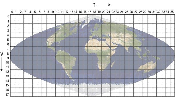
Level 2G, Level 3, and Level 4 Suomi NPP NASA VIIRS land products use this Sinusoidal grid tiling system. Tiles are 10 degrees by 10 degrees at the equator. The tile coordinate system starts at (0,0) (horizontal tile number, vertical tile number) in the upper left corner and proceeds right (horizontal) and downward (vertical). The tile in the bottom right corner is (35,17).
VIIRS Climate Modeling Grid (CMG)
The VIIRS CMG is the same as the MODIS CMG. The CMG datasets provide global coverage in a Geographic Latitude and Longitude projection at a resolution of 0.05 degrees. The geographic coordinates of the upper left corner of the upper left pixel of a VIIRS CMG image are -180.00 degrees longitude, 90.00 degrees latitude. The geographic coordinates of the lower right corner of the lower right pixel are 180.00 degrees longitude, -90.00 degrees latitude.
VIIRS Processing Levels
The VIIRS data distributed by the LP DAAC are available at the following levels:
- Level-2: derived geophysical variables at the same resolution and location as Level-1 source data (swath products)
- Level-2G: Level-2 data mapped on a uniform space-time grid scale (Sinusoidal)
- Level-3: gridded variables in derived spatial and/or temporal resolutions
- Level-4: model output or results from analyses of lower-level data
VIIRS Spectral Bands
| Band | Reflected Range (μm) | Band Explanation |
|---|---|---|
| I1 | 0.6 - 0.68 | Visible/Reflective |
| I2 | 0.85 - 0.88 | Near Infrared |
| I3 | 1.58 - 1.64 | Shortwave Infrared |
| I4 | 3.55 - 3.93 | Medium-wave Infrared |
| I5 | 10.5 - 12.4 | Longwave Infrared |
| M1 | 0.402 - 0.422 | Visible/Reflective |
| M2 | 0.436 - 0.454 | Visible/Reflective |
| M3 | 0.478 - 0.488 | Visible/Reflective |
| M4 | 0.545 - 0.565 | Visible/Reflective |
| M5 | 0.662 - 0.682 | Near Infrared |
| M6 | 0.739 - 0.754 | Near Infrared |
| M7 | 0.846 - 0.885 | Shortwave Infrared |
| M8 | 1.23 - 1.25 | Shortwave Infrared |
| M9 | 1.371 - 1.386 | Shortwave Infrared |
| M10 | 1.58 - 1.64 | Shortwave Infrared |
| M11 | 2.23 - 2.28 | Medium-wave Infrared |
| M12 | 3.61 - 3.79 | Medium-wave Infrared |
| M13 | 3.97 - 4.13 | Longwave Infrared |
| M14 | 8.4 - 8.7 | Longwave Infrared |
| M15 | 10.26 - 11.26 | Longwave Infrared |
| M16 | 11.54 - 12.49 | Day/Night |
| DNB | 0.5 - 0.9 | Visible/Reflective |
VIIRS Metadata
VIIRS products have two sources of metadata: the embedded HDF-EOS5 metadata, and the external Earth Observing System Data and Information System (EOSDIS) metadata, known as the EOSDIS Core System (ECS) metadata. The HDF-EOS5 metadata contains valuable information including global attributes and dataset specific attributes pertaining to the granule. An external metadata file is provided in XML format (.xml) and is provided along with the VIIRS product. This file provides a subset of the HDF-EOS5 metadata. Some key features of VIIRS HDF-EOS5 metadata attributes may include the following:
- The Xdim and Ydim represent the rows and columns of the data, respectively.
- The Projection and ProjParams identify the projection and its corresponding projection parameters.
- The Sinusoidal Projection is used for most of the gridded VIIRS land products and has a unique sphere measuring 6371007.181 meters.
- The UpperLeftPointMtrs is in projection coordinates and identifies the very upper left corner of the upper left pixel of the image data.
- The LowerRightMtrs identifies the very lower right corner of the lower right pixel of the image data. These projection coordinates are the only metadata that accurately reflect the extreme corners of the gridded image.
- Coordinate fields named EastBoundingCoord, WestBoundingCoord, NorthBoundingCoord, and SouthBoundingCoord represent the latitude and longitude coordinates of the geographic tile corresponding to the data.
The dataset attributes contain specific Science Dataset (SDS) information such as the data range and applicable scaling factors for the data. Information for each NASA VIIRS land data product can be found in the VIIRS Product Table.
VIIRS Tools and Services
Data access options such as Data Pool, NASA Earthdata Search, AppEEARS, and EarthExplorer can be found under Tools.
An HDF-EOS5 file contains information essential for NASA data access tools and services. Most software programs that can process standard HDF5 files can read an HDF-EOS5 file. However, it is difficult for a standard HDF5 call to interpret HDF-EOS5 geolocation or temporal information without further knowledge of the file structure.
Certain open source tools and proprietary tools are available for use with VIIRS HDF-EOS5 products:
Open Source Tools:
Proprietary Tools: