Search Data Catalog

Status: Operational Clear filters
Showing 301 - 315 of 484 results
Satellite Icon
NASA Shuttle Radar Topography Mission Global 1 arc second number
Elevation over the Democratic Republic of the Congo.
NASA Shuttle Radar Topography Mission Global 3 arc second
Elevation over eastern Africa.
NASA Shuttle Radar Topography Mission Global 30 arc second
Satellite Icon
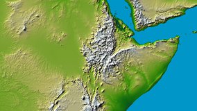
NASA Shuttle Radar Topography Mission Global 3 arc second number
Elevation over the Democratic Republic of the Congo.
NASA Shuttle Radar Topography Mission Global 3 arc second sub-sampled
Radar Brightness Values over the Democratic Republic of the Congo.
NASA Shuttle Radar Topography Mission Combined Image Data Set
Radar Sub-swath Brightness Values over the Democratic Republic of the Congo.
NASA Shuttle Radar Topography Mission Swath Image Data Set
Water Body Attributes over the Democratic Republic of the Congo.
NASA Shuttle Radar Topography Mission Water Body Data Shapefiles and Raster Files
Global view of Percent Tree Cover.
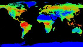
MEaSUREs Vegetation Continuous Fields (VCF) Yearly Global 0.05 Deg
Global view of the Daily NDVI.
Vegetation Index and Phenology (VIP) Vegetation Indices Daily Global 0.05 Deg CMG
Global view of the 7 Day NDVI.
Vegetation Index and Phenology (VIP) Vegetation Indices 7 Days Global 0.05 Deg CMG
Global view of the 15 Day NDVI.
Vegetation Index and Phenology (VIP) Vegetation Indices 15 Days Global 0.05 Deg CMG
Global view of the Monthly NDVI.
Vegetation Index and Phenology (VIP) Vegetation Indices Monthly Global 0.05 Deg CMG
Global view of the Maximum Vegetation Index Season 1.
Vegetation Index and Phenology (VIP) Phenology EVI2 Yearly Global 0.05 Deg CMG
Global view of the Maximum Vegetation Index Season 1.
Vegetation Index and Phenology (VIP) Phenology NDVI Yearly Global 0.05 Deg CMG
Display
15
results per page